IMAGES TAKEN NEAR TO
Holly Park, LONDON, N4 4AQ
Introduction
This page details the photographs taken nearby to Holly Park, N4 4AQ by members of the Geograph project.
The Geograph project started in 2005 with the aim of publishing, organising and preserving representative images for every square kilometre of Great Britain, Ireland and the Isle of Man.

There are currently over 7.5m images from over14,400 individuals and you can help contribute to the project by visiting https://www.geograph.org.uk
Image Map
Images are licensed for reuse under creativecommons.org/licenses/by-sa/2.0
Notes
- Clicking on the map will re-center to the selected point.
- The higher the marker number, the further away the image location is from the centre of the postcode.
Image Listing (186 Images Found)
Images are licensed for reuse under creativecommons.org/licenses/by-sa/2.0
Image
Details
Distance
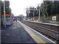
1
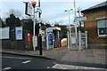
The entrance to Crouch Hill Station
The relatively recently closed ticket office is on the right. An internal wall has been built behind this one to keep vandals out.
Image: © David Howard
Taken: 2 Jan 2021
0.03 miles
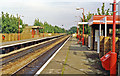
2
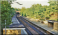
Crouch Hill station
View NE, towards South Tottenham and Barking: ex-Midland and GE (Tottenham & Hampstead Joint line), part of the important east-west freight link across North London with a local passenger service Kentish Town - Barking, later Gospel Oak - Barking.
Image: © Ben Brooksbank
Taken: 13 May 1984
0.03 miles
3
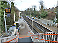
Crouch Hill station
Served by Barking - Gospel Oak Overground trains.
Image: © Robin Webster
Taken: 22 Jan 2011
0.03 miles
4
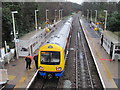
Crouch Hill railway station, Greater London, 2012
Opened in 1868 by the Tottenham and Forest Gate Junction Railway on the line from Gospel Oak to Barking.
View north east towards Harringay Green Lanes and Barking, a few years before the line was electrified. See Image for a post-electrification view in the opposite direction, some 6 years later.
Image: © Nigel Thompson
Taken: 19 Jan 2012
0.03 miles
5
Crouch Hill railway station, Greater London
Opened in 1868 by the Tottenham and Forest Gate Junction Railway on the line from Gospel Oak to Barking.
View south west towards Hornsey Road and Gospel Oak, shortly after the line was electrified. See Image for a pre-electrification view in the opposite direction, some 6 years earlier.
Image: © Nigel Thompson
Taken: 17 Feb 2018
0.03 miles

7
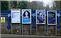
Crouch Hill Station : coronavirus advisory posters
Image: © Jim Osley
Taken: 9 Jan 2021
0.04 miles
8
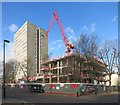
Construction Site on Crouch Hill
This new development has a long way to go to match the bulk of Ilex House, the block next door.
Image: © Des Blenkinsopp
Taken: 2 Feb 2016
0.04 miles
10
Harringay Green Lanes station, 1993
View NE, towards South Tottenham, Barking etc.: ex-Tottenham & Hampstead Junction (GE & Midland Joint) Barking - Kentish Town line, with local trains terminating at Gospel Oak since 1/81. The station was named 'Harringay Park' until 10/58, then 'Harringay Stadium' until 5/90, then 'Harringay East' until 7/91. As with all other stations on the line, it has been renovated since 2008 by London Overground.
Image: © Ben Brooksbank
Taken: 19 Sep 1993
0.04 miles