IMAGES TAKEN NEAR TO
Stapleton Hall Road, LONDON, N4 3QG
Introduction
This page details the photographs taken nearby to Stapleton Hall Road, N4 3QG by members of the Geograph project.
The Geograph project started in 2005 with the aim of publishing, organising and preserving representative images for every square kilometre of Great Britain, Ireland and the Isle of Man.

There are currently over 7.5m images from over14,400 individuals and you can help contribute to the project by visiting https://www.geograph.org.uk
Image Map
Images are licensed for reuse under creativecommons.org/licenses/by-sa/2.0
Notes
- Clicking on the map will re-center to the selected point.
- The higher the marker number, the further away the image location is from the centre of the postcode.
Image Listing (119 Images Found)
Images are licensed for reuse under creativecommons.org/licenses/by-sa/2.0
Image
Details
Distance
1
Stapleton Hall Road from Parkland Walk
Seen from the top of a former Great Northern Railway bridge that is now part of Parkland Walk
Image: © Oxyman
Taken: 22 Apr 2009
0.00 miles
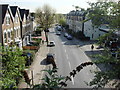
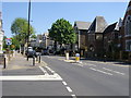
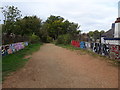
2
View from Parkland Walk, looking southwest
Taken from the same bridge as Image and Image, this shows the southern part of Stapleton Hall Road. Florence Road enters from the left.
Image: © Dr Neil Clifton
Taken: 7 Jan 2012
0.02 miles
3
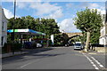
Harvest Petrol Station Stapleton Hall Road London N4
This petrol station is known for being the cheapest in the area and for having appeared in TV dramas. It sits at the intersection of what was once two railways. Behind it to the left lies the Gospel Oak to Barking London Overground line which was once locally known as the Goblin Line but is now officially called the Suffragette Line. To its right stands the beautiful arch of the bridge that once carried the Finsbury Park to Alexandra Palace line that now hosts walkers and cyclists on the Parkland Walk.
Image: © John Kingdon
Taken: 7 Oct 2024
0.04 miles
4
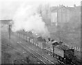
Eastbound freight train on Tottenham & Hampstead line at Harringay Junction, 1947
View westward, probably from Oakfield Road [?] bridge, towards Gospel Oak, Kentish Town and Cricklewood on the former Joint (MR & GER) line across North London, now with a London Overground service Gospel Oak - Barking, an important freight link. Tender-first is ex-Midland 3F 0-6-0 No. 3448 (built by Dubs & Co 1894, withdrawn 1/54).
Image: © Ben Brooksbank
Taken: 8 Nov 1947
0.04 miles
5
Stroud Green Baptist Church
Stroud Green Baptist Church on Stapleton Hall Road
Image: © Shaun Ferguson
Taken: 29 Apr 2009
0.04 miles
6
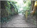
Steps from Parkland Walk to Lancaster Road
Image: © David Howard
Taken: 9 Sep 2014
0.05 miles
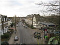
7
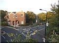
Crouch Hill at the junction of Lancaster Road
Image: © David Howard
Taken: 9 Sep 2014
0.06 miles
8
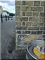
Stapleton Hall Road Railway Bridge Benchmark
Image: © Cipollini
Taken: 14 Jul 2024
0.06 miles
9
Stroud Green railway station (site), Greater London
Opened in 1881 by the Great Northern Railway on the line from Finsbury Park to Alexandra Palace, this station closed in 1954.
View north west towards Crouch End and Alexandra Palace. The wooden platforms of the station started at the end of the bridge parapet, but were destroyed by fire in 1967. The former line is now a public footpath. The white building to the right is the former Station Master's house.
For further information, see http://www.disused-stations.org.uk/s/stroud_green/index.shtml
Image: © Nigel Thompson
Taken: 12 Oct 2018
0.06 miles
10
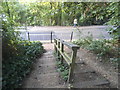
Steps from Parkland Walk to Lancaster Road
Image: © David Howard
Taken: 9 Sep 2014
0.06 miles