IMAGES TAKEN NEAR TO
Regina Road, LONDON, N4 3PT
Introduction
This page details the photographs taken nearby to Regina Road, N4 3PT by members of the Geograph project.
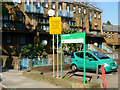
The Geograph project started in 2005 with the aim of publishing, organising and preserving representative images for every square kilometre of Great Britain, Ireland and the Isle of Man.

There are currently over 7.5m images from over14,400 individuals and you can help contribute to the project by visiting https://www.geograph.org.uk
Image Map
Images are licensed for reuse under creativecommons.org/licenses/by-sa/2.0
Notes
- Clicking on the map will re-center to the selected point.
- The higher the marker number, the further away the image location is from the centre of the postcode.
Image Listing (115 Images Found)
Images are licensed for reuse under creativecommons.org/licenses/by-sa/2.0
Image
Details
Distance
1
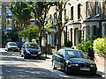
Stonenest Street, Finsbury Park
Short street connecting Evershot Road and Marriott Road, with Victorian housing typical of the area.
Image: © Stephen McKay
Taken: 19 Sep 2008
0.06 miles
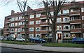
2
Wall Court, Stroud Green Road, N4
At Marquis Road.
Image: © Danny P Robinson
Taken: 3 Dec 2006
0.06 miles
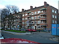
4
Housing estate near Finsbury Park
A housing estate facing onto Stroud Green Road, in the inner suburbs of north London.
Image: © Malc McDonald
Taken: 26 Jan 2019
0.07 miles
5
Newcourt Christian Centre, Regina Road, Stroud Green
An Elim Pentecostal church housed in premises originall built as the New Court Congregational Church in 1961 (?).
Image: © Jim Osley
Taken: 7 May 2017
0.07 miles
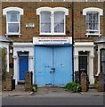
6
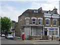
Disused corner shop, Thorpdale Road, Stroud Green
Image: © Jim Osley
Taken: 7 May 2017
0.08 miles
7
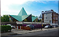
Finsbury Park : Light of the World Church
Image: © Jim Osley
Taken: 29 Jun 2020
0.08 miles
8
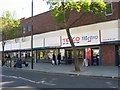
Tesco at Stroud Green, London N4
Shoppers move widdershins around this store.
Image: © Vicky Ayech
Taken: 21 Apr 2005
0.08 miles
9
Searle Place, Finsbury Park
Small modern housing development off Evershot Road.
Image: © Stephen McKay
Taken: 19 Sep 2008
0.08 miles
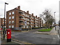
10

V2 Bomb Site
The small public space at the top of Evershot Road, N4, near its junction with Hanley Road serves as a reminder of the V2 strike of 1944. The ballistic missile fell on New Year's Eve, miraculously causing just one fatality - a local chimney-sweep.
Image: © Stuart Shepherd
Taken: 14 Nov 2007
0.08 miles