IMAGES TAKEN NEAR TO
Oxford Road, LONDON, N4 3HA
Introduction
This page details the photographs taken nearby to Oxford Road, N4 3HA by members of the Geograph project.
The Geograph project started in 2005 with the aim of publishing, organising and preserving representative images for every square kilometre of Great Britain, Ireland and the Isle of Man.

There are currently over 7.5m images from over14,400 individuals and you can help contribute to the project by visiting https://www.geograph.org.uk
Image Map
Images are licensed for reuse under creativecommons.org/licenses/by-sa/2.0
Notes
- Clicking on the map will re-center to the selected point.
- The higher the marker number, the further away the image location is from the centre of the postcode.
Image Listing (126 Images Found)
Images are licensed for reuse under creativecommons.org/licenses/by-sa/2.0
Image
Details
Distance
1
Stroud Green Primary School
This is a very large school, and only part of it is seen on this photograph
Image: © Dr Neil Clifton
Taken: 30 Jun 2010
0.04 miles
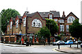
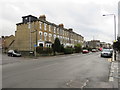
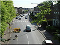
2
Oxford Road, Finsbury Park
Oxford Road is a residential one-way street in inner north London.
Image: © Malc McDonald
Taken: 26 Jan 2019
0.05 miles
3

A sign of the times
Girls entrance to school. Not a sign that would be placed at a school entrance nowadays. I don't think the gate access system is a contemporary feature!
Image: © Alan Hughes
Taken: 13 Oct 2018
0.05 miles
5
Oxford Road, Finsbury Park
From the entrance to Parkland Walk
Image: © David Howard
Taken: 5 Jul 2012
0.06 miles
6
Upper Tollington Park, Finsbury Park
Upper Tollington park is a road in the inner north London suburbs.
Image: © Malc McDonald
Taken: 26 Jan 2019
0.06 miles
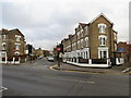
7
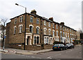
Oxford Road
Not to be confused with Oxford Street! This section is a cul-de-sac off Florence Road, leading to the railway line and a footbridge to Finsbury Park. There is another section of Oxford Road on the opposite side of Florence Road, but interestingly the two sections do not form a straight crossroads, suggesting that one was a later addition to the area. The houses are typical terraced designs for the area, having 3 storeys above street level.
Image: © Martin Addison
Taken: 28 Jan 2011
0.06 miles
8
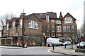
Stroud Green Primary School
Seen here from Florence Road at the junction with Perth Road. The old 'Girls' entrance is visible and reminds of a time of sexual segregation in our mixed schools. The current address for the school is on Woodstock Road, around the corner on the left.
Image: © Martin Addison
Taken: 28 Jan 2011
0.07 miles
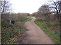
10
Upper Tollington Park from Parkland Walk
Seen from the top of a former Great Northern Railway bridge that is now part of Parkland Walk
Image: © Oxyman
Taken: 22 Apr 2009
0.07 miles