IMAGES TAKEN NEAR TO
Woodstock Road, LONDON, N4 3ET
Introduction
This page details the photographs taken nearby to Woodstock Road, N4 3ET by members of the Geograph project.
The Geograph project started in 2005 with the aim of publishing, organising and preserving representative images for every square kilometre of Great Britain, Ireland and the Isle of Man.

There are currently over 7.5m images from over14,400 individuals and you can help contribute to the project by visiting https://www.geograph.org.uk
Image Map
Images are licensed for reuse under creativecommons.org/licenses/by-sa/2.0
Notes
- Clicking on the map will re-center to the selected point.
- The higher the marker number, the further away the image location is from the centre of the postcode.
Image Listing (292 Images Found)
Images are licensed for reuse under creativecommons.org/licenses/by-sa/2.0
Image
Details
Distance
1
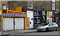
Motors and Billboards
M & S Motors looks like a typical backstreet car repair workshop. Unusual that it isn't open at around 11:00am on a friday. Perhaps the owner has popped out to the cafe for brunch. Some of the adverts seem a bit enigmatic!
Image: © Martin Addison
Taken: 28 Jan 2011
0.03 miles

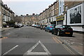
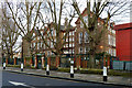
4
Woodstock Road
A terraced street typical of the area with four storey houses, the bottom storey being half below street level.
Image: © Martin Addison
Taken: 28 Jan 2011
0.05 miles
5
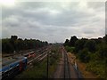
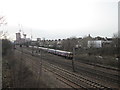
View of the East Coast Mainline from the footbridge adjacent to Finsbury Park
Parkland Walk ends at Finsbury Park, where it meets the path that crosses the East Coast Mainline between Finsbury Park and Harringay stations and enters the park. This is the view from the footbridge on that path, looking south down the tracks. Finsbury Park station can just be seen by the centre two tracks in the middle distance. The suburban North London Line and London Overground use the outer two diverging tracks, whilst the centre tracks are used for express services to the North and intercity services to destinations such as York, Doncaster and Edinburgh.
Image: © Robert Lamb
Taken: 27 Jul 2010
0.07 miles
7
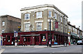
The Worlds End
A common name for pubs in the inner London suburbs. However, this pub was once 'The Earl of Essex' and reputedly has a dark past as a Sin Fein haunt during 'the troubles'. It has also been an Arsenal pub in its time, with the football ground being not too far away. It is currently a popular music venue.
Image: © Martin Addison
Taken: 28 Jan 2011
0.07 miles
8

The Worlds End, Finsbury Park
New Years Eve 2008.
Image: © Chris Whippet
Taken: 31 Dec 2008
0.08 miles
9
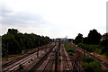
Finsbury Park: View from a footbridge
Looking south from the footbridge across the Great Northern line north of Finsbury Park station, which is seen in the distance.
Image: © Dr Neil Clifton
Taken: 30 Jun 2010
0.08 miles
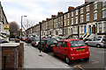
10
Stroud Green Primary School
Viewed from Ennis Road.
Image: © Robin Webster
Taken: 22 Jan 2011
0.08 miles