IMAGES TAKEN NEAR TO
Hanley Road, LONDON, N4 3DQ
Introduction
This page details the photographs taken nearby to Hanley Road, N4 3DQ by members of the Geograph project.
The Geograph project started in 2005 with the aim of publishing, organising and preserving representative images for every square kilometre of Great Britain, Ireland and the Isle of Man.

There are currently over 7.5m images from over14,400 individuals and you can help contribute to the project by visiting https://www.geograph.org.uk
Image Map
Images are licensed for reuse under creativecommons.org/licenses/by-sa/2.0
Notes
- Clicking on the map will re-center to the selected point.
- The higher the marker number, the further away the image location is from the centre of the postcode.
Image Listing (120 Images Found)
Images are licensed for reuse under creativecommons.org/licenses/by-sa/2.0
Image
Details
Distance
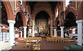
1
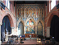
St Saviour, Hanley Road, Tollington, London N4
Image: © John Salmon
Taken: 30 Sep 2014
0.04 miles
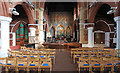
2
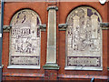
The Old Dairy - old style and present day Delivery
The last two of seven murals on the facade of the Old Dairy Image
Image: © Robin Webster
Taken: 22 Jan 2011
0.04 miles
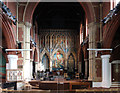
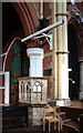
8
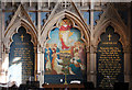
St Saviour, Tollington - Reredos detail
Image: © John Salmon
Taken: 30 Sep 2014
0.04 miles
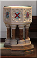
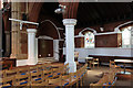
9
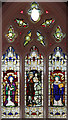
St Saviour, Tollington - Stained glass window
Image: © John Salmon
Taken: 30 Sep 2014
0.04 miles