IMAGES TAKEN NEAR TO
Corbyn Street, LONDON, N4 3DB
Introduction
This page details the photographs taken nearby to Corbyn Street, N4 3DB by members of the Geograph project.
The Geograph project started in 2005 with the aim of publishing, organising and preserving representative images for every square kilometre of Great Britain, Ireland and the Isle of Man.

There are currently over 7.5m images from over14,400 individuals and you can help contribute to the project by visiting https://www.geograph.org.uk
Image Map
Images are licensed for reuse under creativecommons.org/licenses/by-sa/2.0
Notes
- Clicking on the map will re-center to the selected point.
- The higher the marker number, the further away the image location is from the centre of the postcode.
Image Listing (123 Images Found)
Images are licensed for reuse under creativecommons.org/licenses/by-sa/2.0
Image
Details
Distance
1
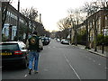
Corbyn Street
Corbyn Street connects Evershot Road and Hornsey Road and runs parallel to Thorpedale Road and Hanley Road.
Image: © Finlay Cox
Taken: 28 Dec 2011
0.02 miles
7
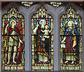
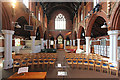
St Saviour, Tollington - Stained glass window
Image: © John Salmon
Taken: 30 Sep 2014
0.05 miles
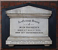
9
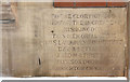
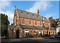
St Saviour, Tollington - Foundation stone
Image: © John Salmon
Taken: 30 Sep 2014
0.05 miles
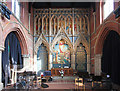
10
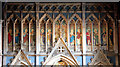
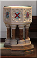
St Saviour, Tollington - Reredos detail
Image: © John Salmon
Taken: 30 Sep 2014
0.05 miles