IMAGES TAKEN NEAR TO
Marquis Road, LONDON, N4 3AP
Introduction
This page details the photographs taken nearby to Marquis Road, N4 3AP by members of the Geograph project.
The Geograph project started in 2005 with the aim of publishing, organising and preserving representative images for every square kilometre of Great Britain, Ireland and the Isle of Man.

There are currently over 7.5m images from over14,400 individuals and you can help contribute to the project by visiting https://www.geograph.org.uk
Image Map
Images are licensed for reuse under creativecommons.org/licenses/by-sa/2.0
Notes
- Clicking on the map will re-center to the selected point.
- The higher the marker number, the further away the image location is from the centre of the postcode.
Image Listing (126 Images Found)
Images are licensed for reuse under creativecommons.org/licenses/by-sa/2.0
Image
Details
Distance

2
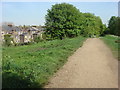
Parkland Walk
A 4.5-mile (7.2 km) linear green walkway along the trackbed of a former Great Northern Railway line.
Image: © Oxyman
Taken: 22 Apr 2009
0.09 miles
3
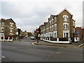
Lancaster Road, N4
At the junction of Upper Tollington Park.
Image: © Danny P Robinson
Taken: 3 Dec 2006
0.09 miles

5
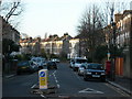
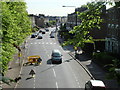
Upper Tollington Park from Parkland Walk
You can see how effective the parking charges are as hardly anyone wants to park there now. There are no shops or other facilities here to expect anyone to want to pay to do so, and if this is typical not many do.
Image: © David Howard
Taken: 5 Jul 2012
0.10 miles
6
Oxford Road, Finsbury Park
Oxford Road is a residential one-way street in inner north London.
Image: © Malc McDonald
Taken: 26 Jan 2019
0.11 miles
7
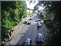
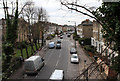
Upper Tollington Park from Parkland Walk
Seen from the top of a former Great Northern Railway bridge that is now part of Parkland Walk
Image: © Oxyman
Taken: 22 Apr 2009
0.11 miles
8
Upper Tollington Park, Finsbury Park
Upper Tollington park is a road in the inner north London suburbs.
Image: © Malc McDonald
Taken: 26 Jan 2019
0.11 miles
9
Upper Tollington Park
Seen from The Parkland Walk on the bridge that used to carry the Finsbury Park to Alexandra Park railway line. The junction in the mioddle distance is with Florence Road.
Image: © Martin Addison
Taken: 28 Jan 2011
0.11 miles
10
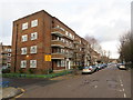
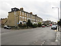
Marquis Road, Finsbury Park
A low-rise block of flats on Marquis Road in inner north London.
Image: © Malc McDonald
Taken: 26 Jan 2019
0.12 miles