IMAGES TAKEN NEAR TO
Brownswood Road, LONDON, N4 2XN
Introduction
This page details the photographs taken nearby to Brownswood Road, N4 2XN by members of the Geograph project.
The Geograph project started in 2005 with the aim of publishing, organising and preserving representative images for every square kilometre of Great Britain, Ireland and the Isle of Man.

There are currently over 7.5m images from over14,400 individuals and you can help contribute to the project by visiting https://www.geograph.org.uk
Image Map
Images are licensed for reuse under creativecommons.org/licenses/by-sa/2.0
Notes
- Clicking on the map will re-center to the selected point.
- The higher the marker number, the further away the image location is from the centre of the postcode.
Image Listing (179 Images Found)
Images are licensed for reuse under creativecommons.org/licenses/by-sa/2.0
Image
Details
Distance
3
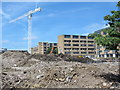
Large building site west of Green Lanes, opposite Clissold Park
Image: © Mike Quinn
Taken: 18 Jun 2015
0.03 miles
4
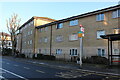
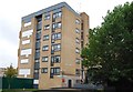
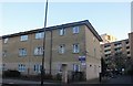
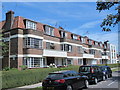
Flats on Brownswood Road, Stoke Newington
Image: © David Howard
Taken: 22 Jan 2023
0.04 miles
5
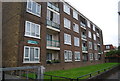
Flats on Brownswood Road, Stoke Newington
Image: © David Howard
Taken: 2 Dec 2019
0.04 miles
6
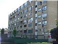
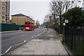
Lemsford Court
Lemsford Court is part of the King's Crescent Estate, which is to be refurbished. This block had been occupied by squatters.
Image: © Malc McDonald
Taken: 23 May 2010
0.05 miles
10
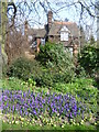
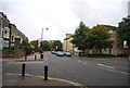
Lodge seen from the entrance to Clissold Park
The mansion in Clissold Park dates from the 1790s. It was then known as Paradise House and was the home of the Crawshays and later of the Reverend Augustus Clissold. The Reverend Clissold fell in love with Eliza Crawshay, one of Mr Crawshay's two daughters, a match of which Mr Crawshay violently disapproved. Apparently Crawshay hated parsons and also had a violent temper. The local curate was banned from the house but the couple continued to communicate via messengers whom Crawshay then threatened to shoot. Eventually old Mr Crawshay died and the couple married so that Clissold became the owner of Paradise House, promptly changing the name to Clissold House and the grounds became Clissold's Park.
After Clissold's death, the property went to another member of the Crawshay family who sold his interest in the estate to the Ecclesiastical Commissioners who had plans to subdivide the land for building. An influential local committee fought for three years to keep the estate as open space for the public. They finally persuaded the Metropolitan Board of Works to acquire the park in 1887. Clissold Park was formally opened to the public by the first chairman of the London County Council, the Earl of Rosebery, on 24th July 1889.
The two ornamental lakes were originally dug to make bricks for the mansion. They had been filled in but on the campaign to save the park succeeding, they were immediately re-excavated. They are actually on the line of the Hackney Brook, one of London's lost rivers which now runs underground. Up until the late 1830s, the Hackney Brook was a substantial river, 30 feet wide wide in full flood here at Stoke Newington. It eventually flowed into the River Lea - see http://en.wikipedia.org/wiki/Hackney_Brook for more information.
This lodge for a park keeper is near the north-western entrance on Green Lanes and is seen here from Green Lanes.
Image: © Marathon
Taken: 18 Mar 2015
0.06 miles