IMAGES TAKEN NEAR TO
Portland Rise, LONDON, N4 2UT
Introduction
This page details the photographs taken nearby to Portland Rise, N4 2UT by members of the Geograph project.
The Geograph project started in 2005 with the aim of publishing, organising and preserving representative images for every square kilometre of Great Britain, Ireland and the Isle of Man.

There are currently over 7.5m images from over14,400 individuals and you can help contribute to the project by visiting https://www.geograph.org.uk
Image Map
Images are licensed for reuse under creativecommons.org/licenses/by-sa/2.0
Notes
- Clicking on the map will re-center to the selected point.
- The higher the marker number, the further away the image location is from the centre of the postcode.
Image Listing (196 Images Found)
Images are licensed for reuse under creativecommons.org/licenses/by-sa/2.0
Image
Details
Distance
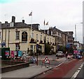
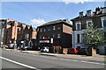
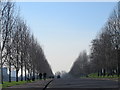
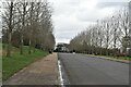
8
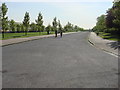
Carriageway, Finsbury Park
The Carriageway in Finsbury Park is circular and a lap of it measures about 1.5 miles
Image: © Oxyman
Taken: 22 Apr 2009
0.09 miles
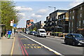
10
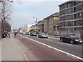
Seven Sisters Road, N4
Near Alexandra Grove, looking towards Manor House.
Image: © Danny P Robinson
Taken: 19 Mar 2009
0.10 miles