IMAGES TAKEN NEAR TO
Wilberforce Road, LONDON, N4 2SW
Introduction
This page details the photographs taken nearby to Wilberforce Road, N4 2SW by members of the Geograph project.
The Geograph project started in 2005 with the aim of publishing, organising and preserving representative images for every square kilometre of Great Britain, Ireland and the Isle of Man.

There are currently over 7.5m images from over14,400 individuals and you can help contribute to the project by visiting https://www.geograph.org.uk
Image Map (Loading...)


Getting Data...Please wait
Leaflet Map data © OpenStreetMap
Images are licensed for reuse under creativecommons.org/licenses/by-sa/2.0
Notes
- Clicking on the map will re-center to the selected point.
- The higher the marker number, the further away the image location is from the centre of the postcode.
Image Listing (290 Images Found)
Images are licensed for reuse under creativecommons.org/licenses/by-sa/2.0
Image
Details
Distance
1
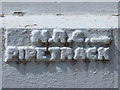
New River Company sign, Wilberforce Road, N4
See Image The sign marks the southern side of the course of the New River which crossed the street here at about 45 degrees, heading towards the building with the green dome at the northern corner of the junction of Seven Sisters Road and Blackstock Road - see Image (photographed by Des Blenkinsopp). The location of the sign is shown in Image, in which it can be seen that the house on the right is almost triangular in shape - see the map and satellite image http://mortimermaps.appspot.com/wtp3/wtp3.htm?lat=51.564723&lon=-0.102060&lz=17&rz=21<=OS&rt=satellite&lov=None&rov=None .
Image: © Mike Quinn
Taken: 18 Jun 2015
0.01 miles
2
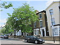
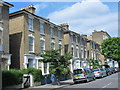
Wilberforce Road, N4 (4)
See Image Shows the location of Image (it's halfway up the low brick wall in front of the painted house on the right - just to the right of the lamppost).
Image: © Mike Quinn
Taken: 18 Jun 2015
0.02 miles
3
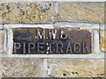
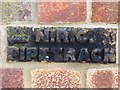
Metropolitan Water Board sign, Wilberforce Road, N4
The sign marks the northern side of the original course of the New River, which crossed the street here at about 45 degrees, heading towards the building with the green dome at the northern corner of the junction of Seven Sisters Road and Blackstock Road - see Image (photographed by Des Blenkinsopp). The location of this sign is shown in Image See also Image and Image
Image: © Mike Quinn
Taken: 18 Jun 2015
0.02 miles
6
New River Company sign, Finsbury Park Road, N4
See Image The sign marks the northern side of the original course of the New River, which crossed the street here at about 45 degrees, heading towards the building with the green dome at the northern corner of the junction of Seven Sisters Road and Blackstock Road - see Image (photographed by Des Blenkinsopp). The location of this sign is shown in Image
Image: © Mike Quinn
Taken: 18 Jun 2015
0.04 miles
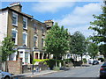
7
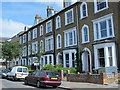
Finsbury Park Road, N4 (3)
Shows the location of Image (it's below the second "pillar" from the right on the low wall in front of the first house on the right).
Image: © Mike Quinn
Taken: 18 Jun 2015
0.04 miles
8
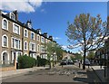
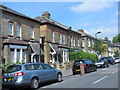
Finsbury Park Road
I sometimes think how nice these roads must have looked before there were cars.
But then there was probably horse poo everywhere, so it's win and lose.
Image: © Des Blenkinsopp
Taken: 18 Apr 2015
0.04 miles
10
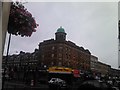
Interesting minaret on the parade of shops at the Seven Sisters Road/Blackstock Road junction
Looking east-northeast from outside The Twelve Pins pub.
Image: © Robert Lamb
Taken: 26 Sep 2010
0.05 miles