IMAGES TAKEN NEAR TO
Woodberry Down, LONDON, N4 2SH
Introduction
This page details the photographs taken nearby to Woodberry Down, N4 2SH by members of the Geograph project.
The Geograph project started in 2005 with the aim of publishing, organising and preserving representative images for every square kilometre of Great Britain, Ireland and the Isle of Man.

There are currently over 7.5m images from over14,400 individuals and you can help contribute to the project by visiting https://www.geograph.org.uk
Image Map
Images are licensed for reuse under creativecommons.org/licenses/by-sa/2.0
Notes
- Clicking on the map will re-center to the selected point.
- The higher the marker number, the further away the image location is from the centre of the postcode.
Image Listing (255 Images Found)
Images are licensed for reuse under creativecommons.org/licenses/by-sa/2.0
Image
Details
Distance
1
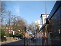
View back up Woodberry Down towards Lordship Road
Looking north-northeast.
Image: © Robert Lamb
Taken: 29 Mar 2014
0.01 miles
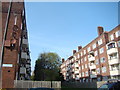
2
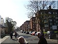
View along Woodberry Down
Woodberry Down is the main street passing through the eponymous Woodberry Down Estate and is lined with 1950s blocks of flats. The newly redeveloped part of the estate is just out of shot to the left. Looking south-southwest.
Image: © Robert Lamb
Taken: 29 Mar 2014
0.03 miles
3
View of the Woodberry Down Estate, Lordship Road from the New River Walkway
Looking north-northeast.
Image: © Robert Lamb
Taken: 15 Jun 2013
0.03 miles
4
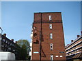
A collection of satellite dishes on the side of Keynsham House
Looking north-northwest. There is a wire dangling rather precariously from the top of the building down to the tangle of wires below the dishes.
Image: © Robert Lamb
Taken: 29 Mar 2014
0.03 miles
5
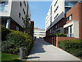
Woodberry Park apartments, Woodberry Down
Apartment blocks on the re-developed Woodberry Down Estate.
Image: © Jim Osley
Taken: 18 Aug 2016
0.04 miles
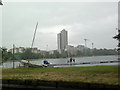
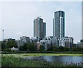
6
Woodberry down east reservoir and flats in the background
Image: © Rob Purvis
Taken: 4 Aug 2018
0.04 miles
7
Looking through the gap between two blocks to Seven Sisters Road #3
This is the gap between Keynsham and Kilpeck Houses. Here a large tree blocks the view to Seven Sisters Road, hence why I took this photo at more of an angle to make it more interesting.
Image: © Robert Lamb
Taken: 29 Mar 2014
0.04 miles
8
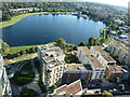
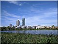
View of Woodberry Wetlands reservoir from 22nd floor
Image: © moska
Taken: 11 Sep 2016
0.04 miles
9
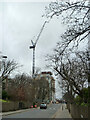
Crane over Woodberry Grove, 2011
Looking along Lordship Lane (the name changes), the crane is engaged in the construction of Residence Tower (flats) which will get much higher before completion.
Image: © Robin Webster
Taken: 5 Feb 2011
0.04 miles
10
View up the pathway to Goodchild Road from the New River Walkway
Looking north-northwest.
Image: © Robert Lamb
Taken: 29 Mar 2014
0.04 miles