IMAGES TAKEN NEAR TO
Romilly Road, LONDON, N4 2QX
Introduction
This page details the photographs taken nearby to Romilly Road, N4 2QX by members of the Geograph project.
The Geograph project started in 2005 with the aim of publishing, organising and preserving representative images for every square kilometre of Great Britain, Ireland and the Isle of Man.

There are currently over 7.5m images from over14,400 individuals and you can help contribute to the project by visiting https://www.geograph.org.uk
Image Map
Images are licensed for reuse under creativecommons.org/licenses/by-sa/2.0
Notes
- Clicking on the map will re-center to the selected point.
- The higher the marker number, the further away the image location is from the centre of the postcode.
Image Listing (193 Images Found)
Images are licensed for reuse under creativecommons.org/licenses/by-sa/2.0
Image
Details
Distance

3

London School Board plaque & LCC shield
Many of the schools erected by the London School Board are decorated with plaques such as these. The LCC or London County Council administration ran from 1889 to 1965.
Image: © Jim Osley
Taken: 16 Jun 2013
0.07 miles

5
Vivian Comma Close at the junction of Blackstock Road
Image: © David Howard
Taken: 13 Jun 2014
0.08 miles

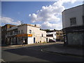
9
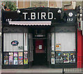
T Bird Bar, Blackstock Road, Finsbury Park, London
Art Deco-style shop converted into a bar
Image: © Jim Osley
Taken: 20 Jun 2009
0.09 miles
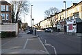
10

Blackstock Road, N4
Near the junction of Ambler Road
Image: © Danny P Robinson
Taken: 19 Mar 2009
0.09 miles