IMAGES TAKEN NEAR TO
St. Thomas's Road, LONDON, N4 2QJ
Introduction
This page details the photographs taken nearby to St. Thomas's Road, N4 2QJ by members of the Geograph project.
The Geograph project started in 2005 with the aim of publishing, organising and preserving representative images for every square kilometre of Great Britain, Ireland and the Isle of Man.

There are currently over 7.5m images from over14,400 individuals and you can help contribute to the project by visiting https://www.geograph.org.uk
Image Map
Images are licensed for reuse under creativecommons.org/licenses/by-sa/2.0
Notes
- Clicking on the map will re-center to the selected point.
- The higher the marker number, the further away the image location is from the centre of the postcode.
Image Listing (284 Images Found)
Images are licensed for reuse under creativecommons.org/licenses/by-sa/2.0
Image
Details
Distance
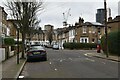
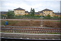
3

Flats by the railway, Finsbury Park
Image: © Christopher Hilton
Taken: 12 Jul 2015
0.05 miles
4
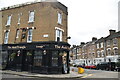
The Auld Triangle, St. Thomas's Road / Plimsoll Road, N4 (2)
Image: © Mike Quinn
Taken: 7 Jun 2017
0.05 miles
7
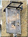
Sign for The Auld Triangle, St. Thomas's Road / Plimsoll Road, N4
See Image Needs a bit of TLC.
Image: © Mike Quinn
Taken: 7 Jun 2017
0.06 miles
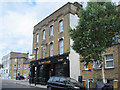
8
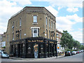
The Auld Triangle, St. Thomas's Road / Plimsoll Road, N4
Image: © Mike Quinn
Taken: 7 Jun 2017
0.06 miles