IMAGES TAKEN NEAR TO
St. Thomas's Road, LONDON, N4 2QG
Introduction
This page details the photographs taken nearby to St. Thomas's Road, N4 2QG by members of the Geograph project.
The Geograph project started in 2005 with the aim of publishing, organising and preserving representative images for every square kilometre of Great Britain, Ireland and the Isle of Man.

There are currently over 7.5m images from over14,400 individuals and you can help contribute to the project by visiting https://www.geograph.org.uk
Image Map (Loading...)


Getting Data...Please wait
Leaflet Map data © OpenStreetMap
Images are licensed for reuse under creativecommons.org/licenses/by-sa/2.0
Notes
- Clicking on the map will re-center to the selected point.
- The higher the marker number, the further away the image location is from the centre of the postcode.
Image Listing (334 Images Found)
Images are licensed for reuse under creativecommons.org/licenses/by-sa/2.0
Image
Details
Distance
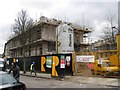
3
St Thomas's Road N4
Looking to the junction with Rock Street
Image: © Robin Sones
Taken: 17 Aug 2013
0.02 miles
5
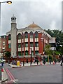
Finsbury Park Mosque, St Thomas's Road N4
Taken from the junction with Rock Street
Image: © Robin Sones
Taken: 17 Aug 2013
0.03 miles
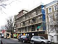
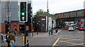
8
St Thomas's Road, N4
This is the way from Finsbury Park Station to the Arsenal Stadium and Arsenal Tube Station.
Image: © Danny P Robinson
Taken: 21 Mar 2008
0.04 miles
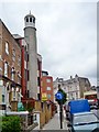
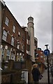
9
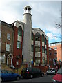
North London Central Mosque, Finsbury Park
This was once called the Finsbury Park Mosque, but in February 2005 the mosque was renamed as the North London Central Mosque. Since then it has been under the control of mainstream Muslims and is now a valuable community resource. But during the late 1990s it fell into the control of radical clerics and was strongly associated with terrorist and other criminal activities. The renaming was intended to distance the Mosque from its past. Read more here:
http://www.nlcentralmosque.com/index.php?option=com_frontpage&Itemid=1
http://en.wikipedia.org/wiki/Finsbury_Park_mosque
Image: © Danny P Robinson
Taken: 21 Mar 2008
0.04 miles
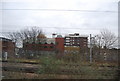
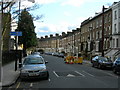
10
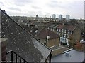
Finsbury Park
View from the sixth floor of City and Islington College
Image: © Vicky Ayech
Taken: 14 Nov 2003
0.04 miles