IMAGES TAKEN NEAR TO
Brownswood Road, LONDON, N4 2PH
Introduction
This page details the photographs taken nearby to Brownswood Road, N4 2PH by members of the Geograph project.
The Geograph project started in 2005 with the aim of publishing, organising and preserving representative images for every square kilometre of Great Britain, Ireland and the Isle of Man.

There are currently over 7.5m images from over14,400 individuals and you can help contribute to the project by visiting https://www.geograph.org.uk
Image Map
Images are licensed for reuse under creativecommons.org/licenses/by-sa/2.0
Notes
- Clicking on the map will re-center to the selected point.
- The higher the marker number, the further away the image location is from the centre of the postcode.
Image Listing (116 Images Found)
Images are licensed for reuse under creativecommons.org/licenses/by-sa/2.0
Image
Details
Distance
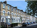
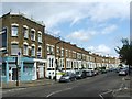
1
Queen's Drive / King's Drive, N4
Shows the location of Image
Image: © Mike Quinn
Taken: 18 Jun 2015
0.07 miles
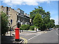
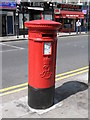
7
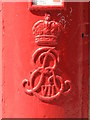
Edward VII postbox, Blackstock Road, N4 - royal cipher
See Image This royal cipher has "sharp" ends to the letters - most are "blobby" - for example, see Image
Image: © Mike Quinn
Taken: 26 Jun 2008
0.09 miles
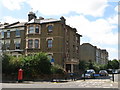
10
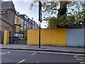
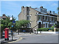
Brownswood Road at the corner of Blackstock Road
Some imagination has gone in to the choice of fencing.
Image: © David Howard
Taken: 7 Nov 2021
0.10 miles