IMAGES TAKEN NEAR TO
New River Way, LONDON, N4 2ND
Introduction
This page details the photographs taken nearby to New River Way, N4 2ND by members of the Geograph project.
The Geograph project started in 2005 with the aim of publishing, organising and preserving representative images for every square kilometre of Great Britain, Ireland and the Isle of Man.

There are currently over 7.5m images from over14,400 individuals and you can help contribute to the project by visiting https://www.geograph.org.uk
Image Map
Images are licensed for reuse under creativecommons.org/licenses/by-sa/2.0
Notes
- Clicking on the map will re-center to the selected point.
- The higher the marker number, the further away the image location is from the centre of the postcode.
Image Listing (155 Images Found)
Images are licensed for reuse under creativecommons.org/licenses/by-sa/2.0
Image
Details
Distance
2
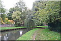
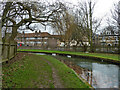
The New River east of Seven Sisters Road (A503)
I've been here before: Image
Image: © Mike Quinn
Taken: 7 Jun 2017
0.02 miles
3
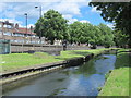
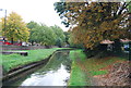
The New River south of Amhurst Park (A107), N16
See Image
Image: © Mike Quinn
Taken: 18 Jun 2015
0.02 miles
4
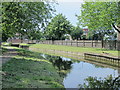
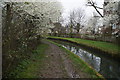
The New River south of Amhurst Park (A107), N16 (3)
See Image
Image: © Mike Quinn
Taken: 18 Jun 2015
0.02 miles
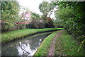
5
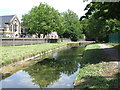
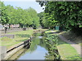
New River
Looking upstream, the channel contours around Woodberry Down.
Image: © Robin Webster
Taken: 5 Feb 2011
0.03 miles
8
The New River east of Seven Sisters Road (A503)
Image: © Mike Quinn
Taken: 18 Jun 2015
0.03 miles
10
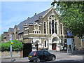
The Sanctuary - Resurrection Power Evangelistic Ministries (UK), Amhurst Road, N16
Image: © Mike Quinn
Taken: 18 Jun 2015
0.04 miles