IMAGES TAKEN NEAR TO
Brownswood Road, LONDON, N4 2HP
Introduction
This page details the photographs taken nearby to Brownswood Road, N4 2HP by members of the Geograph project.
The Geograph project started in 2005 with the aim of publishing, organising and preserving representative images for every square kilometre of Great Britain, Ireland and the Isle of Man.

There are currently over 7.5m images from over14,400 individuals and you can help contribute to the project by visiting https://www.geograph.org.uk
Image Map (Loading...)


Getting Data...Please wait
Leaflet Map data © OpenStreetMap
Images are licensed for reuse under creativecommons.org/licenses/by-sa/2.0
Notes
- Clicking on the map will re-center to the selected point.
- The higher the marker number, the further away the image location is from the centre of the postcode.
Image Listing (157 Images Found)
Images are licensed for reuse under creativecommons.org/licenses/by-sa/2.0
Image
Details
Distance
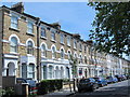
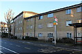
1
Flats on Brownswood Road, Stoke Newington
Image: © David Howard
Taken: 2 Dec 2019
0.02 miles
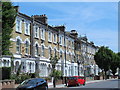
3
Flats on Brownswood Road, Stoke Newington
Image: © David Howard
Taken: 2 Dec 2019
0.05 miles
5
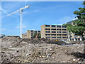
Large building site west of Green Lanes, opposite Clissold Park
Image: © Mike Quinn
Taken: 18 Jun 2015
0.07 miles
7
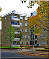
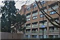
Highbury : Highbury Quadrant Estate
One of the five storey Swedish-influenced blocks built in the 1950s by the London County Council on the Highbury Quadrant Estate.
Image: © Jim Osley
Taken: 23 Oct 2020
0.08 miles
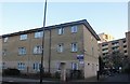
8
Flats on Brownswood Road, Stoke Newington
Image: © David Howard
Taken: 22 Jan 2023
0.08 miles
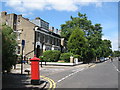
10
King's Crescent, N4
Shows the location of Image
Image: © Mike Quinn
Taken: 26 Jun 2008
0.09 miles