IMAGES TAKEN NEAR TO
Woodberry Down, LONDON, N4 2GQ
Introduction
This page details the photographs taken nearby to Woodberry Down, N4 2GQ by members of the Geograph project.
The Geograph project started in 2005 with the aim of publishing, organising and preserving representative images for every square kilometre of Great Britain, Ireland and the Isle of Man.

There are currently over 7.5m images from over14,400 individuals and you can help contribute to the project by visiting https://www.geograph.org.uk
Image Map
Images are licensed for reuse under creativecommons.org/licenses/by-sa/2.0
Notes
- Clicking on the map will re-center to the selected point.
- The higher the marker number, the further away the image location is from the centre of the postcode.
Image Listing (254 Images Found)
Images are licensed for reuse under creativecommons.org/licenses/by-sa/2.0
Image
Details
Distance
1
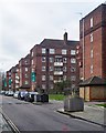
View along Woodberry Down #2
Looking south-southwest.
Image: © Robert Lamb
Taken: 29 Mar 2014
0.02 miles
2
View down Kayani Avenue from Woodberry Down
Looking south-southeast.
Image: © Robert Lamb
Taken: 29 Mar 2014
0.02 miles
3
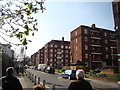
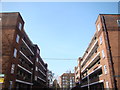
Woodberry Down
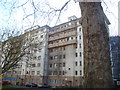
The Woodberry Down Estate was built between 1949 and 1962 by the former London County Council on land either side of Seven Sisters Road. It represented a significant shift away from the pre-war 'garden city' cottage approach to local authority housing, recognising that a denser pattern was needed to solve London's housing crisis. At Woodberry Down all accommodation was in apartment blocks, including these on the north side of Woodberry Down itself; they were originally considered to be models of their kind much loved by those who moved here. However, in more recent years the estate became associated with social deprivation and all the problems that implies. The estate is now being redeveloped by a private developer; some of the replacement blocks can be seen further along the street. Although this will incorporate a relatively high proportion of social housing, the scheme is controversial, described as 'state-led gentrification' because flats in the more desirable locations will be sold at prices way beyond the means of most local people.
Image: © Stephen McKay
Taken: 25 Sep 2015
0.02 miles
4
Woodberry Down Estate, near Manor House
The rise and fall of the Woodberry Down Estate is documented at this https://municipaldreams.wordpress.com//?s=woodberry&search=Go
Image: © Jim Osley
Taken: 2 Jan 2020
0.02 miles
5
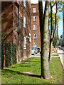
View of Needwood House from Woodberry Down
Quite a stark contrast to the architecture seen so far on the Woodberry Down Estate! Looking south-southeast.
Image: © Robert Lamb
Taken: 29 Mar 2014
0.02 miles
6
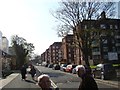
Looking through the gap between two blocks to Seven Sisters Road #5
This is the gap between Knaresborough and Leighfield Houses. There is no road between these two blocks, but a lot of trees instead. Looking north-northwest.
Image: © Robert Lamb
Taken: 29 Mar 2014
0.03 miles
7
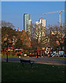
Woodberry Down housing development
View from Finsbury Park. Details at this http://www.e-architect.co.uk/london/woodberry-down-masterplan-hackney. For another view see this http://www.theguardian.com/society/2014/may/18/-sp-truth-about-gentrification-how-woodberry-down-became-woodberry-park. True regeneration or another nail in the coffin for social housing?
Image: © Jim Osley
Taken: 17 Mar 2016
0.03 miles
8
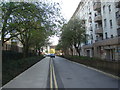
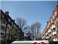
View along Woodberry Down
Woodberry Down is the main street passing through the eponymous Woodberry Down Estate and is lined with 1950s blocks of flats. The newly redeveloped part of the estate is just out of shot to the left. Looking south-southwest.
Image: © Robert Lamb
Taken: 29 Mar 2014
0.04 miles
9
Looking through the gap between two blocks to Seven Sisters Road #6
This is the view between Leighfield and Lonsdale Houses, once again offering a clear view to Seven Sisters Road.
Image: © Robert Lamb
Taken: 29 Mar 2014
0.04 miles
10
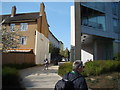
View into Kayani Avenue from the New River Walkway
Looking north-northeast.
Image: © Robert Lamb
Taken: 29 Mar 2014
0.05 miles