IMAGES TAKEN NEAR TO
Myddleton Avenue, LONDON, N4 2FL
Introduction
This page details the photographs taken nearby to Myddleton Avenue, N4 2FL by members of the Geograph project.
The Geograph project started in 2005 with the aim of publishing, organising and preserving representative images for every square kilometre of Great Britain, Ireland and the Isle of Man.

There are currently over 7.5m images from over14,400 individuals and you can help contribute to the project by visiting https://www.geograph.org.uk
Image Map
Images are licensed for reuse under creativecommons.org/licenses/by-sa/2.0
Notes
- Clicking on the map will re-center to the selected point.
- The higher the marker number, the further away the image location is from the centre of the postcode.
Image Listing (174 Images Found)
Images are licensed for reuse under creativecommons.org/licenses/by-sa/2.0
Image
Details
Distance
3
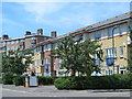
Myddleton Avenue / Green Lanes, N4
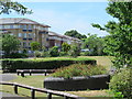
The roughly square area to the west of Green Lanes, bordered to the north by Gloucester Drive and to the south by Digby Crescent, which used to contain filter beds for the New River waterworks in Image (photographed by Malc McDonald), has been redeveloped into housing - see the map and satellite image http://mortimermaps.appspot.com/wtp3/wtp3.htm?lat=51.565102&lon=-0.095456&lz=17&rz=17<=OS&rt=satellite&lov=None&rov=None .
See also Image
Image: © Mike Quinn
Taken: 18 Jun 2015
0.07 miles
4
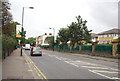
View up Tauheed Close from the entrance to the Castle Climbing Centre car park
Looking south-southwest.
Image: © Robert Lamb
Taken: 29 Mar 2014
0.07 miles
5
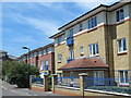
Myddleton Avenue, N4 (2)
See Image Beyond the end of this new road, the original course of the New River ran to the south of the block of flats in the middle distance (left). See Image and Image
Image: © Mike Quinn
Taken: 18 Jun 2015
0.08 miles
9
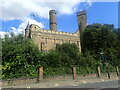
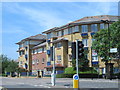
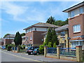
The Castle, Green Lanes
The Castle was built in 1855 as a pumping station. Victorians though wanted to make it a building of distinction so added turrets and battlements. After ceasing to be used for its original purpose it is now an indoor climbing centre. It is seen here looking across Green Lanes.
Image: © Marathon
Taken: 24 Aug 2021
0.10 miles
10
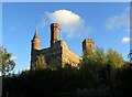
The Castle, Green Lanes
The Castle was built in 1855 as a pumping station. Victorians though wanted to make it a building of distinction so added turrets and battlements. After ceasing to be used for its original purpose it is now an indoor climbing centre. It is seen here looking across Green Lanes.
Image: © Marathon
Taken: 1 Nov 2021
0.10 miles