IMAGES TAKEN NEAR TO
Green Lanes, LONDON, N4 2EX
Introduction
This page details the photographs taken nearby to Green Lanes, N4 2EX by members of the Geograph project.
The Geograph project started in 2005 with the aim of publishing, organising and preserving representative images for every square kilometre of Great Britain, Ireland and the Isle of Man.

There are currently over 7.5m images from over14,400 individuals and you can help contribute to the project by visiting https://www.geograph.org.uk
Image Map
Images are licensed for reuse under creativecommons.org/licenses/by-sa/2.0
Notes
- Clicking on the map will re-center to the selected point.
- The higher the marker number, the further away the image location is from the centre of the postcode.
Image Listing (180 Images Found)
Images are licensed for reuse under creativecommons.org/licenses/by-sa/2.0
Image
Details
Distance
3
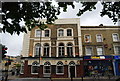
The Brownswood, Green Lanes / Brownswood Road, N4
Image: © Mike Quinn
Taken: 18 Jun 2015
0.02 miles
4
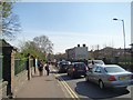
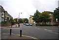
View looking back down Green Lanes towards Stoke Newington
Looking south-southeast. The traffic is queuing for the traffic lights at the corner of Brownswood Road and Lordship Park. There was also a minor collision at the junction between two cars.
Image: © Robert Lamb
Taken: 29 Mar 2014
0.02 miles
5
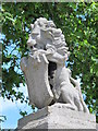
Scary lion, Green Lanes / Lordship Park, N16
See Image
Image: © Mike Quinn
Taken: 18 Jun 2015
0.02 miles
6
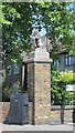
Pillar, Green Lanes / Lordship Park, N16
Image: © Mike Quinn
Taken: 18 Jun 2015
0.02 miles
7
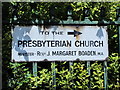
Old sign, Green Lanes / Lordship Park, N16
The sign can just be seen in Image
Image: © Mike Quinn
Taken: 18 Jun 2015
0.02 miles
8
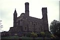
Green Lanes Pumping Station
This was then owned by Thames Water and had been replaced by the new ring main. The old station was deemed too dangerous to enter but we saw a section with diesels being scrapped and old boilers used as oil tanks. This was part of the New River Scheme but is now an indoor climbing centre. I suspect few people realise they are climbing where beam engines once reigned supreme.
Image: © Chris Allen
Taken: 2 Apr 1991
0.03 miles
9
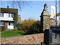
A lion on Green Lanes
This lion on the corner of Green Lanes and Lordship Park looks a little incongruous here. There is no companion on the other side of Lordship Park. I can only assume it remains from some long-lost house.
Image: © Marathon
Taken: 18 Mar 2015
0.03 miles