IMAGES TAKEN NEAR TO
Blackstock Road, LONDON, N4 2DL
Introduction
This page details the photographs taken nearby to Blackstock Road, N4 2DL by members of the Geograph project.
The Geograph project started in 2005 with the aim of publishing, organising and preserving representative images for every square kilometre of Great Britain, Ireland and the Isle of Man.

There are currently over 7.5m images from over14,400 individuals and you can help contribute to the project by visiting https://www.geograph.org.uk
Image Map
Images are licensed for reuse under creativecommons.org/licenses/by-sa/2.0
Notes
- Clicking on the map will re-center to the selected point.
- The higher the marker number, the further away the image location is from the centre of the postcode.
Image Listing (320 Images Found)
Images are licensed for reuse under creativecommons.org/licenses/by-sa/2.0
Image
Details
Distance
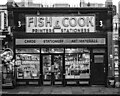
5
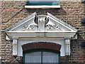
The BlackStock, Seven Sisters Road / Blackstock Road, N4 - detail
See Image
Image: © Mike Quinn
Taken: 18 Jun 2015
0.02 miles
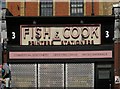
7
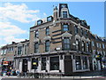
The BlackStock, Seven Sisters Road / Blackstock Road, N4
Image: © Mike Quinn
Taken: 18 Jun 2015
0.02 miles
8
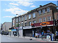
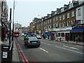
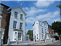
Corner of Blackstock Road
A bit of architectural exuberance here on the corner with Seven Sisters Road.
Opposite, in shadow on the right here, is a similarly imposing pub with a large clock.
Image: © Des Blenkinsopp
Taken: 18 Apr 2015
0.02 miles
9
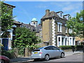
Finsbury Park Road, N4 (2)
See Image The original course of the New River crossed the street here at about 45 degrees, heading towards the building with the green dome at the northern corner of the junction of Seven Sisters Road and Blackstock Road - see Image (photographed by Des Blenkinsopp). As a result, the house on the right is almost triangular in shape - see the map and satellite image http://mortimermaps.appspot.com/wtp3/wtp3.htm?lat=51.564735&lon=-0.103372&lz=17&rz=21<=OS&rt=satellite&lov=None&rov=None . See also Image
Image: © Mike Quinn
Taken: 18 Jun 2015
0.02 miles
10
Wilberforce Road, N4 (2)
See Image Shows the location of Image (it's on the lower part of the low wall [half left] in line with the right hand side of the building behind).
Image: © Mike Quinn
Taken: 18 Jun 2015
0.02 miles