IMAGES TAKEN NEAR TO
Seven Sisters Road, LONDON, N4 2DE
Introduction
This page details the photographs taken nearby to Seven Sisters Road, N4 2DE by members of the Geograph project.
The Geograph project started in 2005 with the aim of publishing, organising and preserving representative images for every square kilometre of Great Britain, Ireland and the Isle of Man.

There are currently over 7.5m images from over14,400 individuals and you can help contribute to the project by visiting https://www.geograph.org.uk
Image Map
Images are licensed for reuse under creativecommons.org/licenses/by-sa/2.0
Notes
- Clicking on the map will re-center to the selected point.
- The higher the marker number, the further away the image location is from the centre of the postcode.
Image Listing (323 Images Found)
Images are licensed for reuse under creativecommons.org/licenses/by-sa/2.0
Image
Details
Distance
3
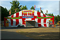
Entrance to Bank Holiday fun fair, Finsbury Park, May 2011
Image: © Jim Osley
Taken: 25 May 2011
0.02 miles
4
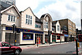
Finsbury Park: 'Rowan's Bowl'
This establishment appears to provide almost every form of entertainment under one roof.
Image: © Dr Neil Clifton
Taken: 30 Jun 2010
0.03 miles
5
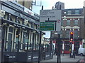
Road sign at the junction of Stroud Green Road and Seven Sisters Road
Unlike the official type this sign uses capital letters.
Image: © David Howard
Taken: 23 Jan 2009
0.03 miles
6
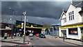
Stroud Green Road railway bridge, Finsbury Park
Stroud Green Road passes under a low bridge. The bridge carries the East Coast main line from London's King's Cross station northwards towards Yorkshire, North East England and Scotland. A protective beam has been placed ahead of the bridge. Any vehicles which are too high to pass beneath the bridge will hit the beam, rather than the bridge itself.
The dark clouds threatened rain.
Image: © Malc McDonald
Taken: 22 Mar 2014
0.03 miles
7
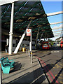
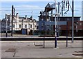
Station Place, Finsbury Park
Finsbury Park station, where National Rail meets the Victoria and Piccadilly lines, is one of the busiest in London outside the central area - especially when Arsenal are playing at the Emirates Stadium. Outside in Station Place there are a number of bus stops - together this forms the Finsbury Park Transport Interchange. The impressive new canopy protects passengers from the rain. The interchange was opened by the Mayor of London, Ken Livingstone, in December 2006.
Image: © Stephen McKay
Taken: 6 Feb 2008
0.04 miles
8
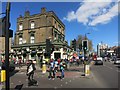
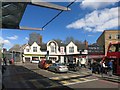
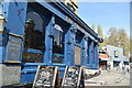
The Twelve Pins
A corner pub on Seven Sisters Road.
An unusual name for a pub, the Twelve Pins are a mountain range in Ireland.
Although on a Saturday afternoon, full of singing, shouting football fans, the Twelve Pints might have been nearer the mark.....
Image: © Des Blenkinsopp
Taken: 18 Apr 2015
0.04 miles
10
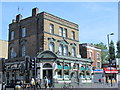
The Twelve Pins, Seven Sisters Road / Stroud Green Road, N4
Image: © Mike Quinn
Taken: 18 Jun 2015
0.04 miles