IMAGES TAKEN NEAR TO
Goodchild Road, LONDON, N4 2BA
Introduction
This page details the photographs taken nearby to Goodchild Road, N4 2BA by members of the Geograph project.
The Geograph project started in 2005 with the aim of publishing, organising and preserving representative images for every square kilometre of Great Britain, Ireland and the Isle of Man.

There are currently over 7.5m images from over14,400 individuals and you can help contribute to the project by visiting https://www.geograph.org.uk
Image Map
Images are licensed for reuse under creativecommons.org/licenses/by-sa/2.0
Notes
- Clicking on the map will re-center to the selected point.
- The higher the marker number, the further away the image location is from the centre of the postcode.
Image Listing (213 Images Found)
Images are licensed for reuse under creativecommons.org/licenses/by-sa/2.0
Image
Details
Distance
1
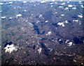
Lea Valley Reservoirs from the air
The 2012 Olympic Games site can be seen still under construction in the lower right corner. Viewed from a Brussels bound flight from Prestwick.
Image: © Thomas Nugent
Taken: 1 Mar 2010
0.01 miles
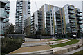
2
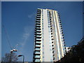
View of Residence Tower from Woodberry Down
Looking north-northeast.
Image: © Robert Lamb
Taken: 29 Mar 2014
0.01 miles
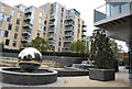
4
Woodberry Down (flats), Woodberry Grove, N4
In the foreground is the "water feature" shown in Image (photographed by Des Blenkinsopp).
Image: © Mike Quinn
Taken: 18 Jun 2015
0.01 miles
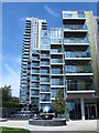
5
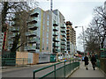
Riverside Apartments and Residence Tower under construction, 2011
The near Riverside Apartments appears externally complete, the far Residence Tower is less advanced and will be much higher.
Image: © Robin Webster
Taken: 5 Feb 2011
0.02 miles
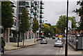
6
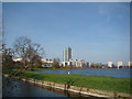
View of the Woodberry Down Estate from the New River Walkway #3
Looking north-northeast.
Image: © Robert Lamb
Taken: 29 Mar 2014
0.02 miles
9
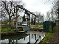
Screen and debris handling grab, New River, 2011
The water conduit formerly passed under Lordship Road via a simple bridge, with a link to the left with the East Reservoir, what happens now here for flow to the other side of the road is not too obvious.
Image: © Robin Webster
Taken: 5 Feb 2011
0.03 miles
10
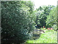
The New River east of Woodberry Grove, N4
See Image
Image: © Mike Quinn
Taken: 18 Jun 2015
0.03 miles