IMAGES TAKEN NEAR TO
Queens Drive, LONDON, N4 2AR
Introduction
This page details the photographs taken nearby to Queens Drive, N4 2AR by members of the Geograph project.
The Geograph project started in 2005 with the aim of publishing, organising and preserving representative images for every square kilometre of Great Britain, Ireland and the Isle of Man.

There are currently over 7.5m images from over14,400 individuals and you can help contribute to the project by visiting https://www.geograph.org.uk
Image Map
Images are licensed for reuse under creativecommons.org/licenses/by-sa/2.0
Notes
- Clicking on the map will re-center to the selected point.
- The higher the marker number, the further away the image location is from the centre of the postcode.
Image Listing (243 Images Found)
Images are licensed for reuse under creativecommons.org/licenses/by-sa/2.0
Image
Details
Distance
1
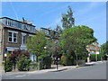
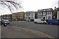
Queen's Drive, N4 (2)
The west side, north of Somerfield Road.
Image: © Mike Quinn
Taken: 18 Jun 2015
0.02 miles
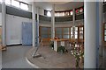
2
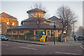
Church of St John the Evangelist, Finsbury Park
Built in 1995 to the designs of architect Tom Hornsby.
Image: © Jim Osley
Taken: 28 Dec 2016
0.03 miles
3
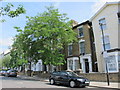
Wilberforce Road, N4 (4)
See Image Shows the location of Image (it's halfway up the low brick wall in front of the painted house on the right - just to the right of the lamppost).
Image: © Mike Quinn
Taken: 18 Jun 2015
0.05 miles
4
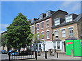
Somerfield Road, N4 (3)
The north side, west of Queen's Drive.
Image: © Mike Quinn
Taken: 18 Jun 2015
0.05 miles
5
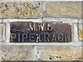
Metropolitan Water Board sign, Wilberforce Road, N4
The sign marks the northern side of the original course of the New River, which crossed the street here at about 45 degrees, heading towards the building with the green dome at the northern corner of the junction of Seven Sisters Road and Blackstock Road - see Image (photographed by Des Blenkinsopp). The location of this sign is shown in Image See also Image and Image
Image: © Mike Quinn
Taken: 18 Jun 2015
0.05 miles
7
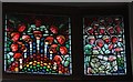
St John the Evangelist, Gloucester Drive, London N4 - Window
Image: © John Salmon
Taken: 24 Jan 2009
0.05 miles
8
Queen's Drive, N4
See Image Shows the location of Image (it's halfway up the low brick wall to the left of the gateway into the house on the left).
Image: © Mike Quinn
Taken: 18 Jun 2015
0.06 miles
9
St John the Evangelist, Gloucester Drive, London N4 - Sanctuary
Image: © John Salmon
Taken: 24 Jan 2009
0.06 miles
10

New River Company sign, Wilberforce Road, N4
See Image The sign marks the southern side of the course of the New River which crossed the street here at about 45 degrees, heading towards the building with the green dome at the northern corner of the junction of Seven Sisters Road and Blackstock Road - see Image (photographed by Des Blenkinsopp). The location of the sign is shown in Image, in which it can be seen that the house on the right is almost triangular in shape - see the map and satellite image http://mortimermaps.appspot.com/wtp3/wtp3.htm?lat=51.564723&lon=-0.102060&lz=17&rz=21<=OS&rt=satellite&lov=None&rov=None .
Image: © Mike Quinn
Taken: 18 Jun 2015
0.06 miles