IMAGES TAKEN NEAR TO
Quill Street, LONDON, N4 2AD
Introduction
This page details the photographs taken nearby to Quill Street, N4 2AD by members of the Geograph project.
The Geograph project started in 2005 with the aim of publishing, organising and preserving representative images for every square kilometre of Great Britain, Ireland and the Isle of Man.

There are currently over 7.5m images from over14,400 individuals and you can help contribute to the project by visiting https://www.geograph.org.uk
Image Map
Images are licensed for reuse under creativecommons.org/licenses/by-sa/2.0
Notes
- Clicking on the map will re-center to the selected point.
- The higher the marker number, the further away the image location is from the centre of the postcode.
Image Listing (219 Images Found)
Images are licensed for reuse under creativecommons.org/licenses/by-sa/2.0
Image
Details
Distance
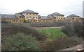
1

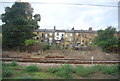
Flats by the railway, Finsbury Park
Image: © Christopher Hilton
Taken: 12 Jul 2015
0.02 miles
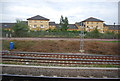
6
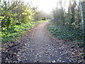
Path in Gillespie Park
Gillespie Park is located immediately adjacent to the East Coast Main Line, just south of Finsbury Park station. The original agricultural land where Gillespie Park is now had been bought in 1866 by the Great Northern Railway and developed into goods and marshalling yards. The East Goods Yard, now occupied by the park, was operational from 1877 until 1960, by which time modernisation and decline in rail freight led to its closure and eventual dereliction.
In 1981 a proportion of the site was leased to Islington Borough Council for an initial period of ten years to be used as an Ecological Park. In 1986 British Rail announced that they wanted to sell the land for housing but local people organised a campaign and saved Gillespie Park. In 1991 the Council obtained Department of the Environment funding to build an Ecology Centre in the park and this was opened in 1993. The park was declared a Local Nature Reserve in 1996.
It is now a peaceful oasis, surrounded by housing and the railway lines out of King's Cross and Moorgate. For more information see http://www.islington.gov.uk/publicrecords/library/Environmental-protection/Information/Leaflets/2012-2013/(2012-10-09)-Islington-Ecology-Centre-and-Gillespie-Park.pdf and http://www.islington.gov.uk/services/parks-environment/parks/islington_nature_reserves/gillespie/Pages/Ecology_centre.aspx
Image: © Marathon
Taken: 10 Dec 2014
0.08 miles

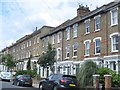
8
In Gillespie Park
Gillespie Park is located immediately adjacent to the East Coast Main Line, just south of Finsbury Park station. The original agricultural land where Gillespie Park is now had been bought in 1866 by the Great Northern Railway and developed into goods and marshalling yards. The East Goods Yard, now occupied by the park, was operational from 1877 until 1960, by which time modernisation and decline in rail freight led to its closure and eventual dereliction.
In 1981 a proportion of the site was leased to Islington Borough Council for an initial period of ten years to be used as an Ecological Park. In 1986 British Rail announced that they wanted to sell the land for housing but local people organised a campaign and saved Gillespie Park. In 1991 the Council obtained Department of the Environment funding to build an Ecology Centre in the park and this was opened in 1993. The park was declared a Local Nature Reserve in 1996.
It is now a peaceful oasis, surrounded by housing and the railway lines out of King's Cross and Moorgate. For more information see http://www.islington.gov.uk/publicrecords/library/Environmental-protection/Information/Leaflets/2012-2013/(2012-10-09)-Islington-Ecology-Centre-and-Gillespie-Park.pdf and http://www.islington.gov.uk/services/parks-environment/parks/islington_nature_reserves/gillespie/Pages/Ecology_centre.aspx
Image: © Marathon
Taken: 10 Dec 2014
0.09 miles
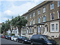
10
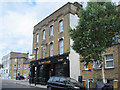
The Auld Triangle, St. Thomas's Road / Plimsoll Road, N4 (2)
Image: © Mike Quinn
Taken: 7 Jun 2017
0.09 miles