IMAGES TAKEN NEAR TO
Umfreville Road, LONDON, N4 1RZ
Introduction
This page details the photographs taken nearby to Umfreville Road, N4 1RZ by members of the Geograph project.
The Geograph project started in 2005 with the aim of publishing, organising and preserving representative images for every square kilometre of Great Britain, Ireland and the Isle of Man.

There are currently over 7.5m images from over14,400 individuals and you can help contribute to the project by visiting https://www.geograph.org.uk
Image Map
Images are licensed for reuse under creativecommons.org/licenses/by-sa/2.0
Notes
- Clicking on the map will re-center to the selected point.
- The higher the marker number, the further away the image location is from the centre of the postcode.
Image Listing (250 Images Found)
Images are licensed for reuse under creativecommons.org/licenses/by-sa/2.0
Image
Details
Distance
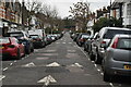
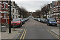
2
Umfreville Road, Harringay
Looking down Umfreville Road past attractive front gardens towards Grand Parade.
Image: © Stephen McKay
Taken: 27 Aug 2011
0.03 miles
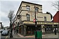
3
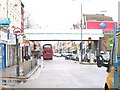
Harringay Green Lanes Station
London N4 shopping centre
Image: © Vicky Ayech
Taken: 19 Apr 2005
0.03 miles
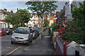
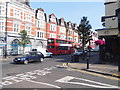
4
Green Lanes, N4
Near the junction with Umfreville Road.
Image: © Danny P Robinson
Taken: 19 Mar 2009
0.03 miles
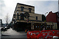
8
Green Lanes at the junction of Burgoyne Road
Image: © David Howard
Taken: 11 Jul 2013
0.05 miles
9
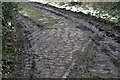
Last Remnant From The Past
Inside the Railway Fields Local Nature Reserve, little remains to remind us of its former use as a Railway goods Depot except for these rails set into the cobbles. It started its life in 1868 as a coal depot. It became a goods depot circa 1880 when Green Lanes (now Harringay Green Lanes) Station was opened. . The depot consisted of a reception loop on the north side of the Barking to Gospel Oak line and a solitary siding surrounded by a cobbled loading area. These rails are part of that siding where it crossed the cobbled road leading up to the depot from Green Lanes. The depot closed on 3rd February 1964 and was derelict until Haringey Council purchased the land in 1975. It became a local nature reserve in 1990.
Image: © Martin Addison
Taken: 12 Feb 2013
0.05 miles
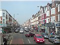
10
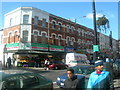
Green Lanes Haringey (1)
This area has many Turkish people, and many of the businesses on Green Lanes are owned by, and cater for, the local Turkish community.
Image: © Danny P Robinson
Taken: 19 Mar 2006
0.05 miles