IMAGES TAKEN NEAR TO
Woodberry Down Estate, LONDON, N4 1QH
Introduction
This page details the photographs taken nearby to Woodberry Down Estate, N4 1QH by members of the Geograph project.
The Geograph project started in 2005 with the aim of publishing, organising and preserving representative images for every square kilometre of Great Britain, Ireland and the Isle of Man.

There are currently over 7.5m images from over14,400 individuals and you can help contribute to the project by visiting https://www.geograph.org.uk
Image Map
Images are licensed for reuse under creativecommons.org/licenses/by-sa/2.0
Notes
- Clicking on the map will re-center to the selected point.
- The higher the marker number, the further away the image location is from the centre of the postcode.
Image Listing (251 Images Found)
Images are licensed for reuse under creativecommons.org/licenses/by-sa/2.0
Image
Details
Distance
3
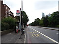
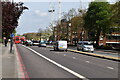
Bus stop and shelter on Seven Sisters Road (A503)
Image: © JThomas
Taken: 20 Jul 2019
0.04 miles
4
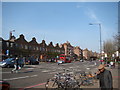
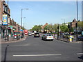
View along Seven Sisters Road from outside Manor House tube station
Looking north-northeast, looking back into the Woodberry Down Estate.
Image: © Robert Lamb
Taken: 29 Mar 2014
0.04 miles
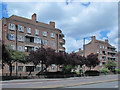
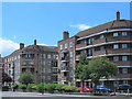
7
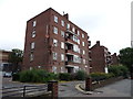
Havering House
Flats on Seven Sisters Road.
Image: © JThomas
Taken: 20 Jul 2019
0.05 miles
8
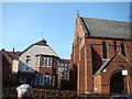
View of St Olave's Church and Cottage from Woodberry Down
Looking north-northeast.
Image: © Robert Lamb
Taken: 29 Mar 2014
0.06 miles
10
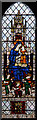
St Olave, Woodberry Down - Stained glass window
Image: © John Salmon
Taken: 18 Mar 2015
0.06 miles