IMAGES TAKEN NEAR TO
Chesterfield Gardens, LONDON, N4 1LR
Introduction
This page details the photographs taken nearby to Chesterfield Gardens, N4 1LR by members of the Geograph project.
The Geograph project started in 2005 with the aim of publishing, organising and preserving representative images for every square kilometre of Great Britain, Ireland and the Isle of Man.

There are currently over 7.5m images from over14,400 individuals and you can help contribute to the project by visiting https://www.geograph.org.uk
Image Map
Images are licensed for reuse under creativecommons.org/licenses/by-sa/2.0
Notes
- Clicking on the map will re-center to the selected point.
- The higher the marker number, the further away the image location is from the centre of the postcode.
Image Listing (83 Images Found)
Images are licensed for reuse under creativecommons.org/licenses/by-sa/2.0
Image
Details
Distance
1
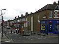
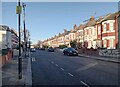
Warwick Gardens, N4
At the junction with St Ann's Road. The retractable bollards are so that residents can access the road without going all the way onto Green Lanes. If there was open access to all vehicles the road would be used as a short cut to avoid the busy junction with Green Lanes.
Image: © Danny P Robinson
Taken: 24 Mar 2008
0.04 miles
3
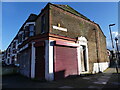
The Workers' Cafe (as was) 329 St Ann's Road N15
This building on the corner of St Ann's Road and Cleveland Gardens was once a cafe called The Workers' Cafe. It has been closed for so many years I can't recall when it was last open. The rotting roof and water damaged brickwork suggest many years of abandonment. Of note is the long windowless wall to the building which I imagine makes the property very gloomy inside. Damp and gloomy; not an impressive selling point for a developer.
Image: © John Kingdon
Taken: 18 Feb 2024
0.06 miles
4
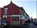
331 St Ann's Road London N15
This shop unit has been closed for so long now that although I remember it being open I can't recall what it sold. Even the housing above it seems unoccupied now although there is plenty of CCTV and barbed wire on the property protecting someone's interest therein. The clock in the transom above the entrance is stuck at three minutes past six. I suspect it will never be used again to tell the time, of which it is now a relic.
Image: © John Kingdon
Taken: 18 Feb 2024
0.07 miles
6
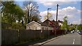
Chapel in the Valley Stanhope Road London N4
Corrugated iron and wooden buildings squashed between the road and the Gospel Oak to Barking railway line used as a church two days a week. Not really in a valley despite its name.The electrification works had yet to go up on the railway embankment behind the buildings.
Image: © John Kingdon
Taken: 19 Apr 2017
0.12 miles
8
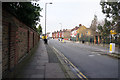
Kimberley Road, N4
The houses on this road were built with balconies over the front door.
Image: © Danny P Robinson
Taken: 24 Mar 2008
0.12 miles
9
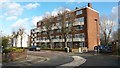
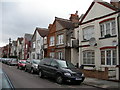
Flats on the corner of Warwick Gardens and Stanhope Gardens
Image: © David Martin
Taken: 25 Jan 2018
0.13 miles
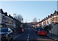
10
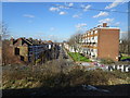
View from a Barking-Gospel Oak train - Warwick Gardens, Harringay
Image: © Nigel Thompson
Taken: 17 Feb 2018
0.13 miles