IMAGES TAKEN NEAR TO
Rutland Gardens, LONDON, N4 1JP
Introduction
This page details the photographs taken nearby to Rutland Gardens, N4 1JP by members of the Geograph project.
The Geograph project started in 2005 with the aim of publishing, organising and preserving representative images for every square kilometre of Great Britain, Ireland and the Isle of Man.

There are currently over 7.5m images from over14,400 individuals and you can help contribute to the project by visiting https://www.geograph.org.uk
Image Map
Images are licensed for reuse under creativecommons.org/licenses/by-sa/2.0
Notes
- Clicking on the map will re-center to the selected point.
- The higher the marker number, the further away the image location is from the centre of the postcode.
Image Listing (132 Images Found)
Images are licensed for reuse under creativecommons.org/licenses/by-sa/2.0
Image
Details
Distance
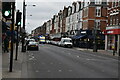
1
Pigeons, Essex Gardens. N4
A short link road with no house addresses.
Image: © Robin Webster
Taken: 22 Jan 2011
0.03 miles
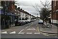
2
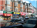
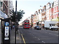
Green Lanes Haringey (4)
This area has many Turkish people, and many of the businesses on Green Lanes are owned by, and cater for, the local Turkish community. Next door to each other in this shot are a Turkish restaurant, 2 internet cafes and a Turkish music shop.
Image: © Danny P Robinson
Taken: 19 Mar 2006
0.06 miles
5
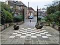
'The Gardens' community garden
Looking out from the garden, most of which is visible. This really is the tiniest park.
Image: © Robin Webster
Taken: 22 Jan 2011
0.09 miles
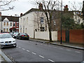
6
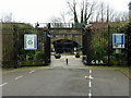
The Gardens Community Garden
A small garden where it looks as if there used to be a way under the railway, now blanked off.
Image: © Robin Webster
Taken: 22 Jan 2011
0.09 miles
7
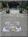
Mosaic, 'The Gardens' community garden
This really is the tiniest park.
Image: © Robin Webster
Taken: 22 Jan 2011
0.09 miles
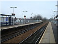
8
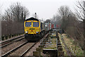
Intermodal Through Harringay
A Freightliner Class 66 (66955) brings the 4M94 Felixstowe South to Lawley Street service through Harringay Green Lanes on a grey and chilly February morning.
The concrete piles on either side of the tracks bear witness to the history of the station. The station opened as Green Lanes in 1880 - originally with wooden platforms and buildings. Concrete and brick structures replaced these in the 1950's when the station was rebuilt and became Harringay Stadium - named after the greyhound racing stadium which was situated right next to the railway. To handle the large number of people attending both the stadium and the adjacent Harringay Arena, the station had extra long platforms. The Arena closed as a sporting venue in 1958 and the Stadium closed in 1987. The platforms were shortened in 2003 due to subsidence (and no real need for them to be so long any more!) The concrete pillars are all that is left of those long platforms. However, some of them have found a new use - the path alongside leads to a raised platform (visible beside the train) to allow crew changes for passing freight trains.
Image: © Martin Addison
Taken: 12 Feb 2013
0.09 miles