IMAGES TAKEN NEAR TO
Wiltshire Gardens, LONDON, N4 1HG
Introduction
This page details the photographs taken nearby to Wiltshire Gardens, N4 1HG by members of the Geograph project.
The Geograph project started in 2005 with the aim of publishing, organising and preserving representative images for every square kilometre of Great Britain, Ireland and the Isle of Man.

There are currently over 7.5m images from over14,400 individuals and you can help contribute to the project by visiting https://www.geograph.org.uk
Image Map
Images are licensed for reuse under creativecommons.org/licenses/by-sa/2.0
Notes
- Clicking on the map will re-center to the selected point.
- The higher the marker number, the further away the image location is from the centre of the postcode.
Image Listing (72 Images Found)
Images are licensed for reuse under creativecommons.org/licenses/by-sa/2.0
Image
Details
Distance
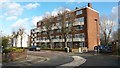
1
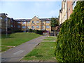
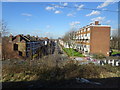
Flats off Finsbury Park Avenue
This estate is between Sainsbury's, the Barking to Gospel Oak Line and Hermitage Road.
Image: © Marathon
Taken: 18 Mar 2015
0.02 miles
2
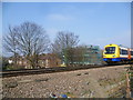
London Overground train near Harringay Green Lanes station
The Tottenham & Hampstead Junction Railway was planned to run from Tottenham Hale on the Great Eastern Railway to Gospel Oak on the Hampstead Junction section of the London & North Western Railway. It was worked by the North London Railway (NLR) from its opening in 1860, and in 1864 came under NLR control. On 21st July 1868 a new line opened from Tottenham Hale to Highgate Road. It was only in 1887 that an extension to Gospel Oak was achieved but as a passenger exchange not as a junction.
On 9th July 1894, the Tottenham & Forest Gate Railway was opened for through goods and passenger trains and had stations at Blackhorse Road, Walthamstow, Leyton, Leytonstone and Wanstead Park. Up to 1912 the line was a joint railway operated by the Midland Railway and the London, Tilbury & Southend Railway but from 1912 it was solely operated by the Midland. With the opening of the new line the Midland extended some of its South Tottenham trains to East Ham.
The line which now ran between Kentish Town and Barking was considered for closure to passengers in 1963 as part of the Beeching Axe, but it remained open. Even so, it was allowed to fall into a poor state of repair and reliability, and by 1980 had been cut back to an hourly service between Kentish Town and Barking. The station canopies were gradually demolished, ticket offices closed and staff withdrawn from stations.
The situation began to improve from 1981 when a new link to Gospel Oak was built and the hourly service from Kentish Town to Barking was replaced by the present route from Gospel Oak to Barking with two trains per hour. Now with it being taken over by Transport for London as part of the London Overground network the whole line has a new lease of life and new trains run every 15 minutes between Barking and Gospel Oak.
This view, from an estate on the south side, sees a train bound for Gospel Oak approaching Harringay Green Lanes station.
Image: © Marathon
Taken: 18 Mar 2015
0.03 miles
3
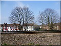
The Barking to Gospel Oak line
The Tottenham & Hampstead Junction Railway was planned to run from Tottenham Hale on the Great Eastern Railway to Gospel Oak on the Hampstead Junction section of the London & North Western Railway. It was worked by the North London Railway (NLR) from its opening in 1860, and in 1864 came under NLR control. On 21st July 1868 a new line opened from Tottenham Hale to Highgate Road. It was only in 1887 that an extension to Gospel Oak was achieved but as a passenger exchange not as a junction.
On 9th July 1894, the Tottenham & Forest Gate Railway was opened for through goods and passenger trains and had stations at Blackhorse Road, Walthamstow, Leyton, Leytonstone and Wanstead Park. Up to 1912 the line was a joint railway operated by the Midland Railway and the London, Tilbury & Southend Railway but from 1912 it was solely operated by the Midland. With the opening of the new line the Midland extended some of its South Tottenham trains to East Ham.
The line which now ran between Kentish Town and Barking was considered for closure to passengers in 1963 as part of the Beeching Axe, but it remained open. Even so, it was allowed to fall into a poor state of repair and reliability, and by 1980 had been cut back to an hourly service between Kentish Town and Barking. The station canopies were gradually demolished, ticket offices closed and staff withdrawn from stations.
The situation began to improve from 1981 when a new link to Gospel Oak was built and the hourly service from Kentish Town to Barking was replaced by the present route from Gospel Oak to Barking with two trains per hour. Now with it being taken over by Transport for London as part of the London Overground network the whole line has a new lease of life and new trains run every 15 minutes between Barking and Gospel Oak.
This view from an estate on the south side looks across the line between Harringay Green Lanes and South Tottenham stations. The houses of Stanhope Gardens can be seen on the other side of the tracks.
Image: © Marathon
Taken: 18 Mar 2015
0.03 miles
4
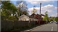
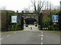
Chapel in the Valley Stanhope Road London N4
Corrugated iron and wooden buildings squashed between the road and the Gospel Oak to Barking railway line used as a church two days a week. Not really in a valley despite its name.The electrification works had yet to go up on the railway embankment behind the buildings.
Image: © John Kingdon
Taken: 19 Apr 2017
0.06 miles
5
View from a Barking-Gospel Oak train - Warwick Gardens, Harringay
Image: © Nigel Thompson
Taken: 17 Feb 2018
0.07 miles
6
The Gardens Community Garden
A small garden where it looks as if there used to be a way under the railway, now blanked off.
Image: © Robin Webster
Taken: 22 Jan 2011
0.08 miles
7
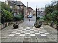
'The Gardens' community garden
Looking out from the garden, most of which is visible. This really is the tiniest park.
Image: © Robin Webster
Taken: 22 Jan 2011
0.08 miles
8
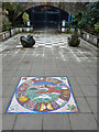
Mosaic, 'The Gardens' community garden
This really is the tiniest park.
Image: © Robin Webster
Taken: 22 Jan 2011
0.08 miles
9
Flats on the corner of Warwick Gardens and Stanhope Gardens
Image: © David Martin
Taken: 25 Jan 2018
0.08 miles
10
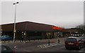
Sainsbury's Harringay
Superstore accessed from Williamson Road.
Image: © David Anstiss
Taken: 3 Feb 2013
0.10 miles