IMAGES TAKEN NEAR TO
Venetia Road, LONDON, N4 1EJ
Introduction
This page details the photographs taken nearby to Venetia Road, N4 1EJ by members of the Geograph project.
The Geograph project started in 2005 with the aim of publishing, organising and preserving representative images for every square kilometre of Great Britain, Ireland and the Isle of Man.

There are currently over 7.5m images from over14,400 individuals and you can help contribute to the project by visiting https://www.geograph.org.uk
Image Map
Images are licensed for reuse under creativecommons.org/licenses/by-sa/2.0
Notes
- Clicking on the map will re-center to the selected point.
- The higher the marker number, the further away the image location is from the centre of the postcode.
Image Listing (246 Images Found)
Images are licensed for reuse under creativecommons.org/licenses/by-sa/2.0
Image
Details
Distance
1
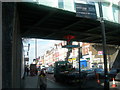
Green Lanes Harringay (5)
The workman on the hoist has the unenviable task of scraping dried pigeon guano from the underside of this bridge, removing the old and evidently ineffective anti-pigeon spikes, and then replacing them.
The railway line is the Gospel Oak to Barking line and Harringay Green Lanes station is just on the other side of the road.
Image: © Danny P Robinson
Taken: 19 Mar 2006
0.04 miles
2
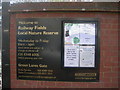
Railway Fields Local Nature Reserve
This nature reserve is literally feet away from the bustle of Green Lanes.
Image: © Danny P Robinson
Taken: 19 Mar 2006
0.04 miles
3
Railway Fields Local Nature Reserve
This is a supplemental image to the photo.
Image: © Danny P Robinson
Taken: 19 Mar 2006
0.04 miles
4
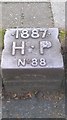
Hornsey Parish marker 1887
Parish boundary marker set into kerbstone on the edge of Finsbury Park showing where the old Parish of Hornsey ended and Tottenham started. It would doubtless shock many living in this ever more trendy and expensive area around Green lanes that they are actually in Tottenham. Few I imagine would even notice the boundary marker.
Image: © John Kingdon
Taken: 7 Sep 2017
0.04 miles
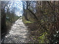
6
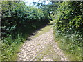
Track to Railway Fields Nature Reserve
There must have once been a siding and industry here, but this is now a nature reserve.
Image: © Danny P Robinson
Taken: 21 May 2009
0.05 miles
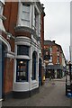
8
Green Lanes
Looking south along the A105 from adjacent to Harringay Green Lanes Station. The Arena shopping area on the left recalls the old Harringay Stadium and Harringay Arena which occupied the site previously. The Beaconsfield Hotel on the right is on the corner of Lothair Road North.
Image: © Martin Addison
Taken: 12 Feb 2013
0.05 miles
9
Last Remnant From The Past
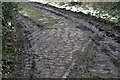
Inside the Railway Fields Local Nature Reserve, little remains to remind us of its former use as a Railway goods Depot except for these rails set into the cobbles. It started its life in 1868 as a coal depot. It became a goods depot circa 1880 when Green Lanes (now Harringay Green Lanes) Station was opened. . The depot consisted of a reception loop on the north side of the Barking to Gospel Oak line and a solitary siding surrounded by a cobbled loading area. These rails are part of that siding where it crossed the cobbled road leading up to the depot from Green Lanes. The depot closed on 3rd February 1964 and was derelict until Haringey Council purchased the land in 1975. It became a local nature reserve in 1990.
Image: © Martin Addison
Taken: 12 Feb 2013
0.06 miles
10
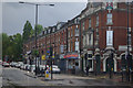
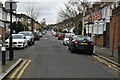
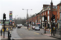
Green Lanes, Harringay
The oddly-named Green Lanes stretches for several miles and forms a principal route through north London. It is seen here at the junction with Lothair Road.
Image: © Stephen McKay
Taken: 27 Aug 2011
0.06 miles