IMAGES TAKEN NEAR TO
Eade Road, LONDON, N4 1DH
Introduction
This page details the photographs taken nearby to Eade Road, N4 1DH by members of the Geograph project.
The Geograph project started in 2005 with the aim of publishing, organising and preserving representative images for every square kilometre of Great Britain, Ireland and the Isle of Man.

There are currently over 7.5m images from over14,400 individuals and you can help contribute to the project by visiting https://www.geograph.org.uk
Image Map
Images are licensed for reuse under creativecommons.org/licenses/by-sa/2.0
Notes
- Clicking on the map will re-center to the selected point.
- The higher the marker number, the further away the image location is from the centre of the postcode.
Image Listing (244 Images Found)
Images are licensed for reuse under creativecommons.org/licenses/by-sa/2.0
Image
Details
Distance
1
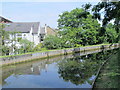
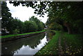
The New River north of Rowley Gardens, N4 (3)
See Image
Image: © Mike Quinn
Taken: 18 Jun 2015
0.03 miles
2
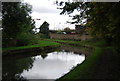
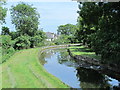
The New River north of Rowley Gardens, N4
See Image
Image: © Mike Quinn
Taken: 18 Jun 2015
0.03 miles
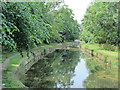
4
The New River north of Rowley Gardens, N4 (2)
See Image
Image: © Mike Quinn
Taken: 18 Jun 2015
0.04 miles
7
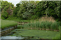
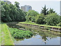
New River near Finsbury Park
Find out more about the New River at this https://www.thehistoryoflondon.co.uk/the-new-river-bringing-fresh-water-to-london/.
Image: © Jim Osley
Taken: 3 Jun 2021
0.05 miles
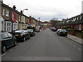
8
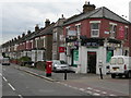
Corner of Vale Road and Hermitage Road, N4
Image: © Danny P Robinson
Taken: 13 Mar 2009
0.05 miles
9
The New River east of Green Lanes (A105) (2)
Image: © Mike Quinn
Taken: 18 Jun 2015
0.05 miles
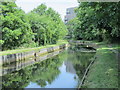
10
The New River south of Eade Road, N4 (11)
See Image
Image: © Mike Quinn
Taken: 18 Jun 2015
0.06 miles