IMAGES TAKEN NEAR TO
Hermitage Road, LONDON, N4 1DB
Introduction
This page details the photographs taken nearby to Hermitage Road, N4 1DB by members of the Geograph project.
The Geograph project started in 2005 with the aim of publishing, organising and preserving representative images for every square kilometre of Great Britain, Ireland and the Isle of Man.

There are currently over 7.5m images from over14,400 individuals and you can help contribute to the project by visiting https://www.geograph.org.uk
Image Map (Loading...)


Getting Data...Please wait
Leaflet Map data © OpenStreetMap
Images are licensed for reuse under creativecommons.org/licenses/by-sa/2.0
Notes
- Clicking on the map will re-center to the selected point.
- The higher the marker number, the further away the image location is from the centre of the postcode.
Image Listing (174 Images Found)
Images are licensed for reuse under creativecommons.org/licenses/by-sa/2.0
Image
Details
Distance
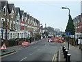
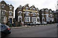
2
Corner of Vale Road and Hermitage Road, N4
Image: © Danny P Robinson
Taken: 13 Mar 2009
0.03 miles
3
Green Lanes, N4
Near Hermitage Road.
Image: © Danny P Robinson
Taken: 19 Mar 2009
0.04 miles
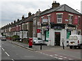
4
Hermitage Road, N4
At the junction with Green Lanes.
Image: © Danny P Robinson
Taken: 19 Mar 2009
0.04 miles
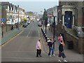
7
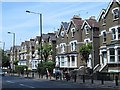
Green Lanes (A105)
The east side, between the New River and Hermitage Road, N4.
Image: © Mike Quinn
Taken: 18 Jun 2015
0.06 miles
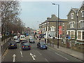
8
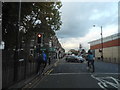
Green Lanes at the junction of Endymion Road
Finsbury Park is on the left
Image: © David Howard
Taken: 2 Oct 2014
0.06 miles
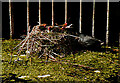
9
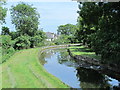
The New River east of Green Lanes (A105) (2)
Image: © Mike Quinn
Taken: 18 Jun 2015
0.07 miles
10
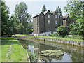
The New River east of Green Lanes (A105)
See Image
Image: © Mike Quinn
Taken: 18 Jun 2015
0.07 miles