IMAGES TAKEN NEAR TO
Burgoyne Road, LONDON, N4 1AE
Introduction
This page details the photographs taken nearby to Burgoyne Road, N4 1AE by members of the Geograph project.
The Geograph project started in 2005 with the aim of publishing, organising and preserving representative images for every square kilometre of Great Britain, Ireland and the Isle of Man.

There are currently over 7.5m images from over14,400 individuals and you can help contribute to the project by visiting https://www.geograph.org.uk
Image Map
Images are licensed for reuse under creativecommons.org/licenses/by-sa/2.0
Notes
- Clicking on the map will re-center to the selected point.
- The higher the marker number, the further away the image location is from the centre of the postcode.
Image Listing (254 Images Found)
Images are licensed for reuse under creativecommons.org/licenses/by-sa/2.0
Image
Details
Distance
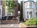
1
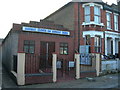
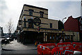
Harringay Seventh-Day Adventist Church
On Cavendish Road, N4
Image: © Danny P Robinson
Taken: 3 Dec 2006
0.02 miles
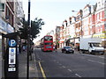
3
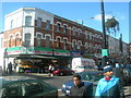
Green Lanes Haringey (1)
This area has many Turkish people, and many of the businesses on Green Lanes are owned by, and cater for, the local Turkish community.
Image: © Danny P Robinson
Taken: 19 Mar 2006
0.04 miles
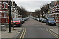
7
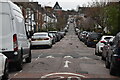
Harringay Passage on Cavendish Road
The passage links all the roads in the Harringay Ladder, with the New River running parallel a hundred yards or so away.
Image: © David Howard
Taken: 11 Jul 2013
0.05 miles
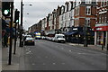
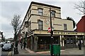
8
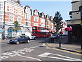
Green Lanes at the junction of Burgoyne Road
Image: © David Howard
Taken: 11 Jul 2013
0.05 miles