IMAGES TAKEN NEAR TO
Trinity Road, LONDON, N22 8XY
Introduction
This page details the photographs taken nearby to Trinity Road, N22 8XY by members of the Geograph project.
The Geograph project started in 2005 with the aim of publishing, organising and preserving representative images for every square kilometre of Great Britain, Ireland and the Isle of Man.

There are currently over 7.5m images from over14,400 individuals and you can help contribute to the project by visiting https://www.geograph.org.uk
Image Map
Images are licensed for reuse under creativecommons.org/licenses/by-sa/2.0
Notes
- Clicking on the map will re-center to the selected point.
- The higher the marker number, the further away the image location is from the centre of the postcode.
Image Listing (128 Images Found)
Images are licensed for reuse under creativecommons.org/licenses/by-sa/2.0
Image
Details
Distance

3
Piccadilly Line electrical substation, near Bounds Green
Image: © Jim Osley
Taken: 18 Apr 2011
0.05 miles
9
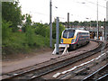
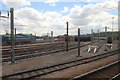
Bounds Green sidings
The northernmost end of the Bounds Green railway depot complex is this single siding alongside the Hertford Loop line (from which the photo was taken).
The train shown here is a class 180 "Adelante" diesel unit leased to Hull Trains.
Image: © Stephen Craven
Taken: 4 Jun 2011
0.11 miles