IMAGES TAKEN NEAR TO
Nightingale Road, LONDON, N22 8PT
Introduction
This page details the photographs taken nearby to Nightingale Road, N22 8PT by members of the Geograph project.
The Geograph project started in 2005 with the aim of publishing, organising and preserving representative images for every square kilometre of Great Britain, Ireland and the Isle of Man.

There are currently over 7.5m images from over14,400 individuals and you can help contribute to the project by visiting https://www.geograph.org.uk
Image Map
Images are licensed for reuse under creativecommons.org/licenses/by-sa/2.0
Notes
- Clicking on the map will re-center to the selected point.
- The higher the marker number, the further away the image location is from the centre of the postcode.
Image Listing (125 Images Found)
Images are licensed for reuse under creativecommons.org/licenses/by-sa/2.0
Image
Details
Distance
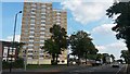
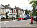
1
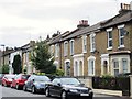
Nightingale Road, N22 (2)
The north side, west of Image
Image: © Mike Quinn
Taken: 15 Jul 2015
0.04 miles
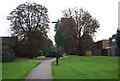
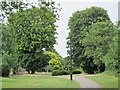
4
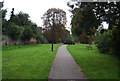
Nightingale Gardens (4)
South of Nightingale Road. See Image
Image: © Mike Quinn
Taken: 15 Jul 2015
0.06 miles
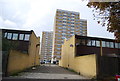
6
Finsbury House, seen across Bounds Green Road
Image: © David Martin
Taken: 9 Sep 2014
0.06 miles
9
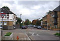
Truro Road / Clarence Road, N22 (2)
Shows the location of Image
Image: © Mike Quinn
Taken: 15 Jul 2015
0.07 miles
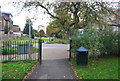
10
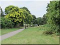
Nightingale Gardens (3)
North of Trinity Road. See Image
Image: © Mike Quinn
Taken: 15 Jul 2015
0.08 miles