IMAGES TAKEN NEAR TO
Dorset Road, LONDON, N22 7SL
Introduction
This page details the photographs taken nearby to Dorset Road, N22 7SL by members of the Geograph project.
The Geograph project started in 2005 with the aim of publishing, organising and preserving representative images for every square kilometre of Great Britain, Ireland and the Isle of Man.

There are currently over 7.5m images from over14,400 individuals and you can help contribute to the project by visiting https://www.geograph.org.uk
Image Map
Images are licensed for reuse under creativecommons.org/licenses/by-sa/2.0
Notes
- Clicking on the map will re-center to the selected point.
- The higher the marker number, the further away the image location is from the centre of the postcode.
Image Listing (220 Images Found)
Images are licensed for reuse under creativecommons.org/licenses/by-sa/2.0
Image
Details
Distance
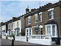
1
Dorset Road London N22 Street Sign Mystery
Under the street sign is another that says 'formerly'. On a 1964 London A-Z the road is given as Dorset Road but an 1895 map gives the road as Ellesborough Road. I'm left wondering how long the 'formerly' sign has been attached to the house, presumably at least sixty years.
Image: © John Kingdon
Taken: 18 Oct 2023
0.02 miles
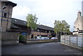
3
Palace Gates (Wood Green) railway station (site), Greater London
Opened in 1878 by the Great Eastern Railway as the terminus of a short branch line from Seven Sisters, this station closed to passengers in 1963 and completely in 1964.
View north west from what was the back of one platform, near the north end of the station. The houses sit on the alignment of the track bed and southbound platform.
For further information, see http://www.disused-stations.org.uk/p/palace_gates/index.shtml.
Image: © Nigel Thompson
Taken: 12 Oct 2018
0.03 miles
4
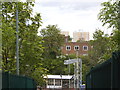
The view from Alexandra Palace station
Called Wood Green, Wood Green (Alexandra Park) and finally inheriting the name of the old station actually by the palace, this is the old British Rail station closest to the palace, with Wood Green tube station being some way down the road in the town centre. It is also the joint closest station to Muswell Hill along with East Finchley on the opposite side. Plans were in place for a railway line from Finsbury Park but was never implemented despite building the first station at Highgate which was completed and not used.
Image: © David Howard
Taken: 7 May 2014
0.03 miles
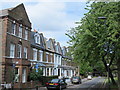
5
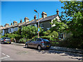
Dorset Road, London N22
Dorset Road is north-east of Alexandra Palace Station, adjacent to some parkland.
Image: © Christine Matthews
Taken: 1 Aug 2013
0.04 miles
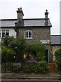
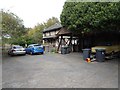
6
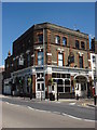
The Gate
Located on Station Rd, describes itself as "Pub & Pizza Kitchen"
Image: © Oxyman
Taken: 29 Apr 2009
0.04 miles
7
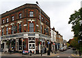
The Gate
Public house located opposite Alexandra Palace station on the corner of St. Michael's Street, which can be seen on the right of the photo.
Image: © Martin Addison
Taken: 28 Oct 2010
0.04 miles