IMAGES TAKEN NEAR TO
Park Avenue, LONDON, N22 7HA
Introduction
This page details the photographs taken nearby to Park Avenue, N22 7HA by members of the Geograph project.
The Geograph project started in 2005 with the aim of publishing, organising and preserving representative images for every square kilometre of Great Britain, Ireland and the Isle of Man.

There are currently over 7.5m images from over14,400 individuals and you can help contribute to the project by visiting https://www.geograph.org.uk
Image Map
Images are licensed for reuse under creativecommons.org/licenses/by-sa/2.0
Notes
- Clicking on the map will re-center to the selected point.
- The higher the marker number, the further away the image location is from the centre of the postcode.
Image Listing (241 Images Found)
Images are licensed for reuse under creativecommons.org/licenses/by-sa/2.0
Image
Details
Distance
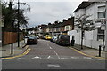
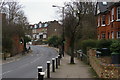
1
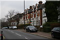
Victorian villas on Park Avenue, Wood Green
In the distance, the road drops to the former site of a railway bridge, which carried the branch line to the now-closed Palace Gates station.
Image: © Christopher Hilton
Taken: 9 Feb 2017
0.04 miles
4
Bridge abutment of dismantled railway, Park Avenue, N22
Image: © Mike Quinn
Taken: 15 Jul 2015
0.07 miles
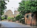
6
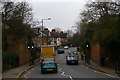
Site of railway bridge, Park Avenue, Wood Green
On either side of the road at the pedestrian crossing can be seen the abutments of a former railway bridge: this marks the course of the Palace Gates line, built by the Great Eastern Railway and running from Seven Sisters to Palace Gates, the latter very close to this point. Competition with the Great Northern Railway's route to Alexandra Palace (the modern East Coast Main Line) and, latterly, the Piccadilly Line, meant that the line struggled to earn its keep; it closed to passengers in 1963 and to freight shortly after.
Image: © Christopher Hilton
Taken: 9 Feb 2017
0.08 miles
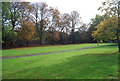
7
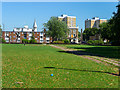
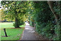
Parkland, London N22
This parkland leads through to the Bounds Green Road.
Image: © Christine Matthews
Taken: 1 Aug 2013
0.08 miles
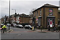
10
Park Avenue, Wood Green, London N22
On either side of the road at the pedestrian crossing can be seen the abutments of a former railway bridge: this marks the course of the Palace Gates line, built by the Great Eastern Railway and running from Seven Sisters to Palace Gates, the latter very close to this point. Competition with the Great Northern Railway's route to Alexandra Palace (the modern East Coast Main Line) and, latterly, the Piccadilly Line, meant that the line struggled to earn its keep; it closed to passengers in 1963 and to freight shortly after.
Image: © Christopher Hilton
Taken: 9 Feb 2017
0.08 miles