IMAGES TAKEN NEAR TO
Northcott Avenue, LONDON, N22 7AP
Introduction
This page details the photographs taken nearby to Northcott Avenue, N22 7AP by members of the Geograph project.
The Geograph project started in 2005 with the aim of publishing, organising and preserving representative images for every square kilometre of Great Britain, Ireland and the Isle of Man.

There are currently over 7.5m images from over14,400 individuals and you can help contribute to the project by visiting https://www.geograph.org.uk
Image Map
Images are licensed for reuse under creativecommons.org/licenses/by-sa/2.0
Notes
- Clicking on the map will re-center to the selected point.
- The higher the marker number, the further away the image location is from the centre of the postcode.
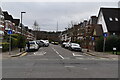
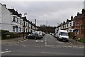
Image Listing (183 Images Found)
Images are licensed for reuse under creativecommons.org/licenses/by-sa/2.0
Image
Details
Distance
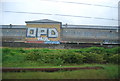
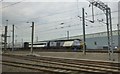
6
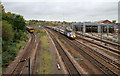
Bounds Green
A local unit takes to the Hertford Loop on the left of the photo - it will cross the main line via the bridge in the distance. Meanwhile, a london bound East Coast express made up of an HST passes the railway depot which services the electric express trains.
Image: © Martin Addison
Taken: 28 Oct 2010
0.07 miles
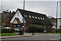
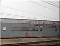
8

Disused church hall, Braemar Avenue, Wood Green
Image: © Jim Osley
Taken: 18 Apr 2011
0.08 miles
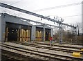
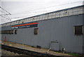
9
Railway depot at Alexandra Palace
Beside the East Coast Main line.
Image: © Russel Wills
Taken: 17 May 2014
0.09 miles