IMAGES TAKEN NEAR TO
Rusper Road, LONDON, N22 6RA
Introduction
This page details the photographs taken nearby to Rusper Road, N22 6RA by members of the Geograph project.
The Geograph project started in 2005 with the aim of publishing, organising and preserving representative images for every square kilometre of Great Britain, Ireland and the Isle of Man.

There are currently over 7.5m images from over14,400 individuals and you can help contribute to the project by visiting https://www.geograph.org.uk
Image Map (Loading...)


Getting Data...Please wait
Leaflet Map data © OpenStreetMap
Images are licensed for reuse under creativecommons.org/licenses/by-sa/2.0
Notes
- Clicking on the map will re-center to the selected point.
- The higher the marker number, the further away the image location is from the centre of the postcode.
Image Listing (27 Images Found)
Images are licensed for reuse under creativecommons.org/licenses/by-sa/2.0
Image
Details
Distance
1
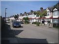
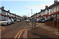
Wood Green: Sandringham Road, N22
The north side of Sandringham Road shown here features a dead straight and level line of between the wars housing.
Image: © Nigel Cox
Taken: 6 Sep 2006
0.05 miles
2
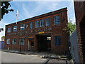
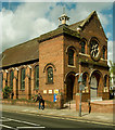
Barber, Wilsons & Co Ltd London N22
This company of 'engineers and brassfounders' is hanging on in area where factories get replaced by housing. Just to the left in the shot was a London taxi repair centre that has recently been demolished for redevelopment. Under the Royal Coat of Arms on the front wall of the nicely proportioned red brick building it states, "BY APPOINTMENT TO HER MAJESTY QUEEN ELIZABETH II MANUFACTURER OF KITCHEN AND BATHROOM TAPS AND MIXERS". Does the new King support this local enterprise?
Image: © John Kingdon
Taken: 3 Sep 2023
0.11 miles
3

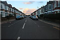
Downhills Park Road, Tottenham
The park is on the left
Image: © David Howard
Taken: 23 Jan 2021
0.12 miles
4

Tottenham: Walpole Road, N17
The telegraph poles have unusual finials on their tops in this road.
Image: © Nigel Cox
Taken: 6 Sep 2006
0.12 miles
5
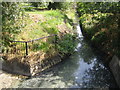
The Moselle in Tottenham
The Moselle is a minor tributary of the River Lee and is culverted through much of its length. It is seen here, hardly flowing, at the west end of Lordship Recreation Ground.
Image: © Nigel Cox
Taken: 6 Sep 2006
0.16 miles

10
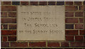
Building stone, Westbury Avenue Baptist Church
Image: © Jim Osley
Taken: 7 May 2013
0.18 miles