IMAGES TAKEN NEAR TO
High Road, LONDON, N22 6DF
Introduction
This page details the photographs taken nearby to High Road, N22 6DF by members of the Geograph project.
The Geograph project started in 2005 with the aim of publishing, organising and preserving representative images for every square kilometre of Great Britain, Ireland and the Isle of Man.

There are currently over 7.5m images from over14,400 individuals and you can help contribute to the project by visiting https://www.geograph.org.uk
Image Map
Images are licensed for reuse under creativecommons.org/licenses/by-sa/2.0
Notes
- Clicking on the map will re-center to the selected point.
- The higher the marker number, the further away the image location is from the centre of the postcode.
Image Listing (193 Images Found)
Images are licensed for reuse under creativecommons.org/licenses/by-sa/2.0
Image
Details
Distance
1
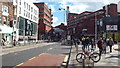
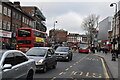
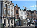
Wood Green High Road
Wood Green High Road is a busy shopping street in North London. In the background the road is flanked by The Mall, a shopping centre previously known as Wood Green Shopping City.
Image: © Malc McDonald
Taken: 22 Mar 2014
0.02 miles
2
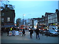
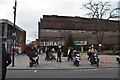
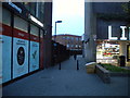
High Road, Wood Green
Looking towards the Underground station from outside the library during a busy afternoon.
Image: © Richard Vince
Taken: 9 Nov 2018
0.02 miles
3
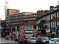
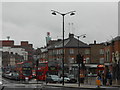
The Broadway, Wood Green
Busy early evening traffic grinds up from The Mall (formerly known as Wood Green Shopping City) towards Wood Green station. The massive shopping centre, built in the 1970s, is now dominated by Primark, a discount clothing store. A row of more traditional shops occupies the foreground.
Image: © Stephen McKay
Taken: 22 Sep 2015
0.02 miles
4
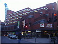
Noel Park and Wood Green railway station (site), Greater London
Opened in 1878 by the Great Eastern Railway on the short branch line from Seven Sisters to Palace Gates, this station closed to passengers in 1963 and completely at the end of 1964.
View south east towards the station. The railway was on a viaduct at this point, crossing the road at an angle. The platforms on the viaduct started where the red building now is and stretched away from us. A single storey entrance building was provided at ground level to the left of the viaduct, where the glass-fronted building now is. As can be seen, all trace of a railway at this point has been erased.
For further information, see http://www.disused-stations.org.uk/n/noel_park_and_wood_green/index.shtml.
Image: © Nigel Thompson
Taken: 12 Oct 2018
0.03 miles
6
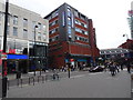
Footpath to Parkland Road, Wood Green
Passing the library on its way from High Road.
Image: © Richard Vince
Taken: 9 Nov 2018
0.03 miles