1
Frome Road
Looking down from Westbury Avenue to the cycle routes by Frome Road
Image: © Shaun Ferguson
Taken: 11 May 2009
0.02 miles
2
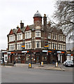
Former public house, Frobisher Road
The former "Queen's Head" public house converted into a furniture store.
Image: © Jim Osley
Taken: 21 Feb 2016
0.04 miles
3
Looking along the line of the old Palace Gates to Seven Sisters railway line
The railway line between Seven Sisters and Palace Gates was opened by the Great Eastern Railway on 1st January 1878 and closed by British Railways to passengers on 7th January 1963 and completely on 5th October 1964. Apart from its route and some of the bridges, very little evidence that it ever existed remains.
This is the view from the bridge carrying Westbury Avenue over the line and looks in the direction of West Green station. The back of the houses in Mannock Road are to the left and those of Graham Road to the right.
A full account of the line with photographs can be seen at http://www.disused-stations.org.uk/w/west_green/index.shtml
Image: © Marathon
Taken: 8 Apr 2015
0.07 miles
4
Boundary Road, Tottenham
Image: © David Howard
Taken: 23 Jan 2021
0.09 miles
5
Noel Park
The Noel Park Estate was built by the Artisan Company between 1881 and 1927. It was specifically designed to provide affordable and fashionable for working class families wishing to leave the inner city. It was designed by Rowland Plumbe and the estate holds some 2,000 properties. Plumbe designed the estate with five different classes of house. Although they vary in size all the houses were designed with front and back gardens. Each of the streets were given their own distinct look.
Noel Park was named after Ernest Noel, Liberal MP and Chairman of the Artisan Company from 1880. The streets were named after board members and people connected to the Artisan Company, as well as prominent politicians of the time - hence Gladstone Avenue and Salisbury Road. Throughout the estate, except for corner houses, each house was built in pairs, with each sharing a porch.
The estate was formally declared open on 4th August 1883 after 200 houses had been completed and another 400 were under construction. A ceremony was held on the site where St Mark's Church now stands. The church was consecrated on 1st November 1889 and by the turn of the 20th century had a congregation twice the size of any other church in Wood Green.
In 1982 in recognition of its architectural and historic interest Noel Park was declared a Conservation Area. This photograph is where Willingdon Road meets Meads Road.
Image: © Marathon
Taken: 8 Apr 2015
0.11 miles
6
The Noel Park Estate
The Noel Park Estate was built by the Artisan Company between 1881 and 1927. It was specifically designed to provide affordable and fashionable for working class families wishing to leave the inner city. It was designed by Rowland Plumbe and the estate holds some 2,000 properties. Plumbe designed the estate with five different classes of house. Although they vary in size all the houses were designed with front and back gardens. Each of the streets were given their own distinct look.
Noel Park was named after Ernest Noel, Liberal MP and Chairman of the Artisan Company from 1880. The streets were named after board members and people connected to the Artisan Company, as well as prominent politicians of the time - hence Gladstone Avenue and Salisbury Road. Throughout the estate, except for corner houses, each house was built in pairs, with each sharing a porch.
The estate was formally declared open on 4th August 1883 after 200 houses had been completed and another 400 were under construction. A ceremony was held on the site where St Mark's Church now stands. The church was consecrated on 1st November 1889 and by the turn of the 20th century had a congregation twice the size of any other church in Wood Green.
In 1982 in recognition of its architectural and historic interest Noel Park was declared a Conservation Area. This photograph is where Willingdon Road meets Meads Road.
Image: © Marathon
Taken: 8 Apr 2015
0.12 miles
7
Langham Road, South Tottenham
Image: © David Howard
Taken: 23 Jan 2021
0.12 miles
8
Langham Road facing east
Image: © Tom Page
Taken: 21 Dec 2021
0.12 miles
9
Wall Advertising Space Repurposed Near Turnpike Lane
The mural on the old advertising space looks a little tatty and the subject matter reminds me of 1970's sloganeering. The face within the star within the eyeball asking us to envision peace I imagine goes completely unnoticed. The graffiti art on the wall below has a date, 31.7.2022, but the 'Turnpike Art Group' board seems long abandoned.
Image: © John Kingdon
Taken: 9 Nov 2023
0.13 miles
10
Turnpike Lane Underground Station, Graham Road N15
Image: © Robin Sones
Taken: 23 Nov 2010
0.14 miles


