IMAGES TAKEN NEAR TO
Station Road, LONDON, N22 6AF
Introduction
This page details the photographs taken nearby to Station Road, N22 6AF by members of the Geograph project.
The Geograph project started in 2005 with the aim of publishing, organising and preserving representative images for every square kilometre of Great Britain, Ireland and the Isle of Man.

There are currently over 7.5m images from over14,400 individuals and you can help contribute to the project by visiting https://www.geograph.org.uk
Image Map
Images are licensed for reuse under creativecommons.org/licenses/by-sa/2.0
Notes
- Clicking on the map will re-center to the selected point.
- The higher the marker number, the further away the image location is from the centre of the postcode.
Image Listing (221 Images Found)
Images are licensed for reuse under creativecommons.org/licenses/by-sa/2.0
Image
Details
Distance
3
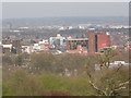
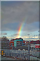
Blocks in Wood Green from Alexandra Park
Looking across the whole of east London
Image: © David Howard
Taken: 10 Apr 2015
0.03 miles
4
Wood Green : public house shield plaque
The public house closed in 2019.
Image: © Jim Osley
Taken: 6 Nov 2020
0.04 miles
6
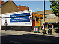
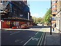
Wood Green Mini Cabs
Located on Station Road
Image: © Oxyman
Taken: 29 Apr 2009
0.07 miles
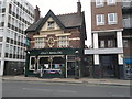
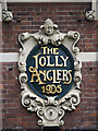
7
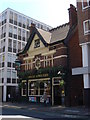
Jolly Anglers
Pub located at 33 Station Road, according to Fancyapint? the British pub guide this is "one perhaps best left to the regulars" http://www.fancyapint.com/pubs/pub2018.html
Image: © Oxyman
Taken: 29 Apr 2009
0.08 miles
8
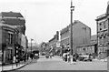
London (Haringey), 1955: Wood Green
View westward along Station Road from Wood Green (N22) High Road (A105), to Alexandra Palace in the distance.
Image: © Ben Brooksbank
Taken: 13 Jul 1955
0.08 miles
10
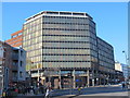
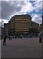
River Park House, High Road / Station Road, N22
Exquisitely named (there's neither a park nor a river in the vicinity) this rectilinear steel and reflective glass monstrosity on giant stilts, situated on the opposite side of the road from the superb Image, is a hideous example of the late 20th C "f*ck you" style. To rub salt into the wounds, it involved the demolition of the magnificent old Wood Green Library in the early 1970s.
It must rank high on the list of buildings that should never have been built. Which enlightened Planning Department gave the required permission you may ask? Answer: Haringey Council.
Who occupies the building? [I suspect that you're ahead of me here.] Yes, it's the main offices of ... Haringey Council.
The Wood Green Audit http://hfra.wikispaces.com/planning+-+Local+Issues+-+Wood+Green+Audit [Part 2, Section 10] says that this "dingy depressing monolith [is] many people’s candidate for the worst 20th Century building in Haringey". And that "a culture of developer-led philistinism seems to determine Council attitudes to local heritage" https://www.flickr.com/photos/alanstanton/22117868375 .
Image: © Mike Quinn
Taken: 18 Jan 2017
0.08 miles