IMAGES TAKEN NEAR TO
Perth Road, LONDON, N22 5QF
Introduction
This page details the photographs taken nearby to Perth Road, N22 5QF by members of the Geograph project.
The Geograph project started in 2005 with the aim of publishing, organising and preserving representative images for every square kilometre of Great Britain, Ireland and the Isle of Man.

There are currently over 7.5m images from over14,400 individuals and you can help contribute to the project by visiting https://www.geograph.org.uk
Image Map
Images are licensed for reuse under creativecommons.org/licenses/by-sa/2.0
Notes
- Clicking on the map will re-center to the selected point.
- The higher the marker number, the further away the image location is from the centre of the postcode.
Image Listing (21 Images Found)
Images are licensed for reuse under creativecommons.org/licenses/by-sa/2.0
Image
Details
Distance
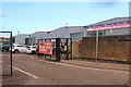
1
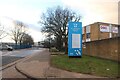
The entrance to St George's Industrial Estate, Tottenham
Image: © David Howard
Taken: 23 Jan 2021
0.05 miles
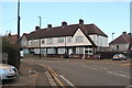
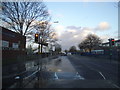
2
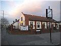
The Pentecostal Church on Perth Road
On the corner of The Crossway
Image: © David Howard
Taken: 20 Jan 2016
0.05 miles
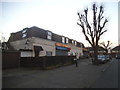
5
St George's Industrial Estate, Tottenham
Image: © David Howard
Taken: 23 Jan 2021
0.07 miles
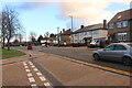
6
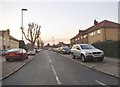
The Crossway, Wood Green
This is just west of the Tottenham border
Image: © David Howard
Taken: 20 Jan 2016
0.09 miles
8
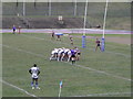
Scrum Down at New River Stadium, White Hart Lane
Image: © Michael Steele
Taken: 14 Feb 2010
0.12 miles

10
White Hart Lane by the Community Sports Centre
Image: © David Howard
Taken: 7 Jan 2014
0.15 miles