IMAGES TAKEN NEAR TO
Crofts Lane, LONDON, N22 5AF
Introduction
This page details the photographs taken nearby to Crofts Lane, N22 5AF by members of the Geograph project.
The Geograph project started in 2005 with the aim of publishing, organising and preserving representative images for every square kilometre of Great Britain, Ireland and the Isle of Man.

There are currently over 7.5m images from over14,400 individuals and you can help contribute to the project by visiting https://www.geograph.org.uk
Image Map
Images are licensed for reuse under creativecommons.org/licenses/by-sa/2.0
Notes
- Clicking on the map will re-center to the selected point.
- The higher the marker number, the further away the image location is from the centre of the postcode.
Image Listing (40 Images Found)
Images are licensed for reuse under creativecommons.org/licenses/by-sa/2.0
Image
Details
Distance
1

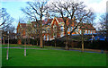
Wood Green : dome, St Thomas More Catholic School
Built as Wood Green County School in 1912 to the designs of Middlesex County Council architect Harry George Crothall. Baroque in style.
Image: © Jim Osley
Taken: 27 Dec 2020
0.03 miles
2
Wood Green : St Thomas More Catholic School
Built as Wood Green County School in 1912 to the designs of Middlesex County Council architect Harry George Crothall. Baroque in style.
Image: © Jim Osley
Taken: 27 Dec 2020
0.03 miles
3
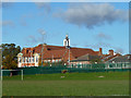
St. Thomas More R.C. School
It is a public playing field in the foreground.
Image: © Robin Webster
Taken: 3 Nov 2012
0.04 miles
4
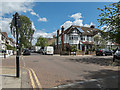
Woodside Road, Bowes Park, London N22
Looking east from the High Road.
Image: © Christine Matthews
Taken: 9 May 2015
0.07 miles
5
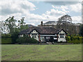
Pavilion, Woodside Park, London N22
Image: © Christine Matthews
Taken: 9 May 2015
0.09 miles
6
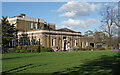
Woodside House extension, Wood Green
"Woodside House was built as a private residence in the ‘Italianate’ style around 1865 ... In 1893 the house was bought by the Wood Green Local Board of Health. In 1892 it housed the area’s first public library, and in 1913 a single storey extension was added to house a new council chamber for Wood Green Urban District Council ..." - quoted from this http://www.haringey.gov.uk/libraries-sport-and-leisure/culture-and-entertainment/visiting-haringey/archive-and-local-history/history-woodside-house
Image: © Jim Osley
Taken: 31 Mar 2017
0.11 miles
7
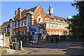
Sir Thomas More Catholic School, Wood Green
Built as Wood Green County School in 1912 to the designs of Middlesex County Council architect Harry George Crothall. Baroque in style.
Image: © Jim Osley
Taken: 23 Jul 2014
0.11 miles
8
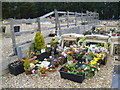
Wood Green Cemetery
Wood Green Cemetery was only opened in 1996. As can be seen, the grounds are finished in pebbles with flowering trees and shrubs. It includes a separate Muslim area as seen at http://www.geograph.org.uk/photo/4420471 This is in the general part of the cemetery.
Image: © Marathon
Taken: 8 Apr 2015
0.12 miles
9
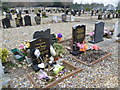
Wood Green Cemetery
Wood Green Cemetery was only opened in 1996. As can be seen, the grounds are finished in pebbles with flowering trees and shrubs. It includes a separate Muslim area as seen at http://www.geograph.org.uk/photo/4420471 This is in the general part of the cemetery.
Image: © Marathon
Taken: 8 Apr 2015
0.12 miles
10
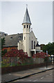
St Barnabas Greek Orthodox Church, near Wood Green
Image: © Jim Osley
Taken: 30 Sep 2010
0.12 miles