IMAGES TAKEN NEAR TO
Orpington Road, LONDON, N21 3PH
Introduction
This page details the photographs taken nearby to Orpington Road, N21 3PH by members of the Geograph project.
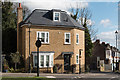
The Geograph project started in 2005 with the aim of publishing, organising and preserving representative images for every square kilometre of Great Britain, Ireland and the Isle of Man.

There are currently over 7.5m images from over14,400 individuals and you can help contribute to the project by visiting https://www.geograph.org.uk
Image Map
Images are licensed for reuse under creativecommons.org/licenses/by-sa/2.0
Notes
- Clicking on the map will re-center to the selected point.
- The higher the marker number, the further away the image location is from the centre of the postcode.
Image Listing (175 Images Found)
Images are licensed for reuse under creativecommons.org/licenses/by-sa/2.0
Image
Details
Distance
1
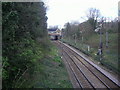
Railway line looking towards the bridge on Station Road
Image: © David Howard
Taken: 9 Apr 2008
0.03 miles
2
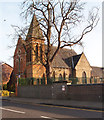
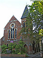
United Reformed Church, Winchmore Hill
Built as a Congregational Church in 1873. History of the church at this http://www.winchmorehillurc.co.uk/the-church.
Image: © Jim Osley
Taken: 13 Mar 2017
0.04 miles
3
United Reformed Church, Winchmore Hill
Built as a Congregational Church in 1873. History of the church at this http://www.winchmorehillurc.co.uk/the-church.
Image: © Jim Osley
Taken: 13 Mar 2017
0.04 miles
4
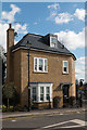
New House in Old Style, Compton Terrace, Winchmore Hill, London N21
Image: © Christine Matthews
Taken: 9 Mar 2017
0.07 miles
5
New House in Old Style, Compton Terrace, Winchmore Hill, London N21
Image: © Christine Matthews
Taken: 9 Mar 2017
0.07 miles
6

Compton Terrace, Winchmore Hill, London N21
Image: © Christine Matthews
Taken: 9 Mar 2017
0.07 miles
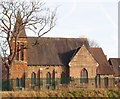
7
United Reformed Church, Compton Road, Winchmore Hill, N21
Image: © Christine Matthews
Taken: 11 Jul 2006
0.08 miles
8
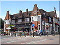
Salisbury Arms, Winchmore Hill
The pub, which was built in the 19th. century, is located on Hoppers Road. Its interior has been restored and refurbished but the building retains its original Victorian facade.
Sources: https://www.thesalisburyarmswinchmorehill.co.uk/
https://whatpub.com/pubs/ENF/7417/salisbury-arms-winchmore-hill
Image: © Paul Bryan
Taken: 23 Jul 2017
0.08 miles
9
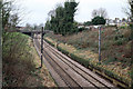
Hertford Loop at Winchmore Hill
A view from the bridge on Station Road, Winchmore Hill. The line carries local suburban services from Kings Cross or Moorgate to Stevenage, Letchworth or Hertford North. It is also used by freight trains avoiding the busy East Coast mainline and is a useful diversion for that route in the event of engineering works. The bridge in the distance carries Compton Road over the line.
Image: © Martin Addison
Taken: 12 Feb 2011
0.09 miles
10

"Salisbury Arms" public house, Winchmore Hill
Neo-Jacobean in style.
Image: © Jim Osley
Taken: 13 Mar 2017
0.10 miles