IMAGES TAKEN NEAR TO
Orpington Road, LONDON, N21 3PG
Introduction
This page details the photographs taken nearby to Orpington Road, N21 3PG by members of the Geograph project.
The Geograph project started in 2005 with the aim of publishing, organising and preserving representative images for every square kilometre of Great Britain, Ireland and the Isle of Man.

There are currently over 7.5m images from over14,400 individuals and you can help contribute to the project by visiting https://www.geograph.org.uk
Image Map
Images are licensed for reuse under creativecommons.org/licenses/by-sa/2.0
Notes
- Clicking on the map will re-center to the selected point.
- The higher the marker number, the further away the image location is from the centre of the postcode.
Image Listing (210 Images Found)
Images are licensed for reuse under creativecommons.org/licenses/by-sa/2.0
Image
Details
Distance
6
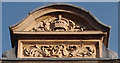
Decorative feature, former Winchmore Hill sorting office
Featuring a crown and Royal cipher. A fuller view and descriptive notes may be found at Image
Image: © Jim Osley
Taken: 13 Mar 2017
0.11 miles
8
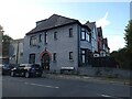
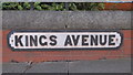
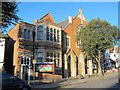
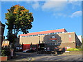
Royal Mail Winchmore Hill Delivery Office, Station Road / King's Avenue, N21
Image: © Mike Quinn
Taken: 14 Oct 2015
0.11 miles
9
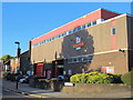
Royal Mail Winchmore Hill Delivery Office, Station Road / King's Avenue, N21 (2)
Shows the location of Image
Image: © Mike Quinn
Taken: 14 Oct 2015
0.11 miles
10
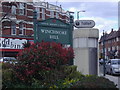
Sign for Winchmore hill with public toilet, Green Lanes
Image: © David Howard
Taken: 9 Apr 2008
0.11 miles