IMAGES TAKEN NEAR TO
Broadway Mews, LONDON, N21 3PB
Introduction
This page details the photographs taken nearby to Broadway Mews, N21 3PB by members of the Geograph project.
The Geograph project started in 2005 with the aim of publishing, organising and preserving representative images for every square kilometre of Great Britain, Ireland and the Isle of Man.

There are currently over 7.5m images from over14,400 individuals and you can help contribute to the project by visiting https://www.geograph.org.uk
Image Map
Images are licensed for reuse under creativecommons.org/licenses/by-sa/2.0
Notes
- Clicking on the map will re-center to the selected point.
- The higher the marker number, the further away the image location is from the centre of the postcode.
Image Listing (156 Images Found)
Images are licensed for reuse under creativecommons.org/licenses/by-sa/2.0
Image
Details
Distance
1
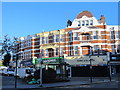
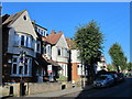
Flats and shops, Green Lanes / Compton Road, N21 (2)
Image: © Mike Quinn
Taken: 14 Oct 2015
0.04 miles
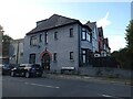
2
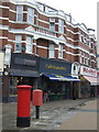
Businesses on Green Lanes, Winchmore Hill
Showing position of Postbox No. N21 8.
See Image] for postbox.
Image: © JThomas
Taken: 27 Jul 2019
0.04 miles
4
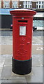
Edward VII postbox on Green Lanes, Winchmore Hill
Postbox No. N21 8.
See Image] for context.
Image: © JThomas
Taken: 27 Jul 2019
0.04 miles
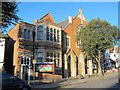
7
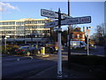
Fingerpost at junction of Station Road and Green Lanes
Image: © David Howard
Taken: 6 Jan 2009
0.05 miles
9
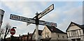
Fingerpost, London N21
This is one of the signposts which were restored.
Image: © Christine Matthews
Taken: 15 Jan 2021
0.06 miles
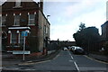
10
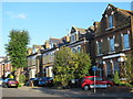
Station Road, N21 (3)
The north side, west of Hazelgreen Close.
Image: © Mike Quinn
Taken: 14 Oct 2015
0.06 miles