IMAGES TAKEN NEAR TO
Vicars Moor Lane, LONDON, N21 2QH
Introduction
This page details the photographs taken nearby to Vicars Moor Lane, N21 2QH by members of the Geograph project.
The Geograph project started in 2005 with the aim of publishing, organising and preserving representative images for every square kilometre of Great Britain, Ireland and the Isle of Man.

There are currently over 7.5m images from over14,400 individuals and you can help contribute to the project by visiting https://www.geograph.org.uk
Image Map
Images are licensed for reuse under creativecommons.org/licenses/by-sa/2.0
Notes
- Clicking on the map will re-center to the selected point.
- The higher the marker number, the further away the image location is from the centre of the postcode.
Image Listing (163 Images Found)
Images are licensed for reuse under creativecommons.org/licenses/by-sa/2.0
Image
Details
Distance
1
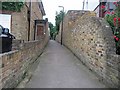
Vicar's Moor Lane, London N21 - Footpath
Image: © John Salmon
Taken: 1 Jun 2008
0.04 miles
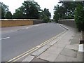
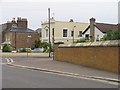
3

Stratfield Park Close junction with Vicar's Moor Lane, London N21
Image: © John Salmon
Taken: 1 Jun 2008
0.06 miles
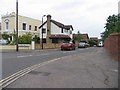
5

George V postbox on Green Moor Link, Winchmore Hill
Postbox No. N21 21.
See Image] for context.
Image: © JThomas
Taken: 27 Jul 2019
0.08 miles
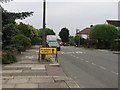
8

Green Moor Link, Winchmore Hill
Showing position of Postbox No. N21 21.
See Image] for postbox.
Image: © JThomas
Taken: 27 Jul 2019
0.09 miles
9
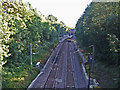
Train leaving Winchmore Hill Station towards Enfield Chase
Looking southwards over the bridge towards Winchmore Hill Station, with a train leaving the station on the northbound track.
Image: © Christine Matthews
Taken: 11 Jul 2006
0.09 miles
10
St. Pauls Primary School
A Church of England primary school in the Winchmore Hill area on Ringwood Way. The single storey classrooms suggest that this school was built in the late 1950's, early 1960's.
Image: © Martin Addison
Taken: 12 Feb 2011
0.10 miles